You are here: Home > Network List > TA - USArray Transportable Network (new EarthScope stations) Stations List
> Station Q38A Cook's Store, Concordia, MO, USA > Earthquake Result Viewer
Q38A Cook's Store, Concordia, MO, USA - Earthquake Result Viewer
| Earthquake location: |
Near Coast Of Peru |
| Earthquake latitude/longitude: |
-14.4/-76.0 |
| Earthquake time(UTC): |
2011/10/28 (301) 18:54:34 GMT |
| Earthquake Depth: |
24 km |
| Earthquake Magnitude: |
6.5 MB, 6.9 MS, 6.9 MW, 6.9 MW |
| Earthquake Catalog/Contributor: |
WHDF/NEIC |
|
| Network: |
TA USArray Transportable Network (new EarthScope stations) |
| Station: |
Q38A Cook's Store, Concordia, MO, USA |
| Lat/Lon: |
38.96 N/93.62 W |
| Elevation: |
228 m |
|
| Distance: |
55.6 deg |
| Az: |
343.355 deg |
| Baz: |
159.149 deg |
| Ray Param: |
0.06463644 |
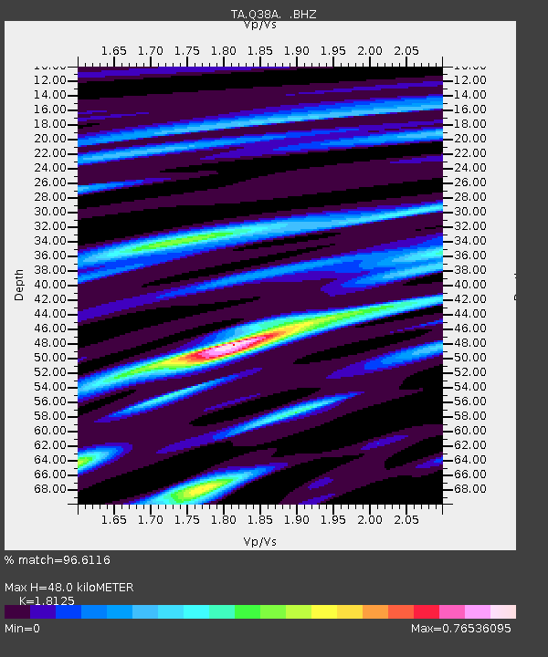
| Estimated Moho Depth: |
48.0 km |
| Estimated Crust Vp/Vs: |
1.81 |
| Assumed Crust Vp: |
6.498 km/s |
| Estimated Crust Vs: |
3.585 km/s |
| Estimated Crust Poisson's Ratio: |
0.28 |
|
| Radial Match: |
96.6116 % |
| Radial Bump: |
293 |
| Transverse Match: |
83.41867 % |
| Transverse Bump: |
400 |
| SOD ConfigId: |
424168 |
| Insert Time: |
2012-02-16 11:01:46.537 +0000 |
| GWidth: |
2.5 |
| Max Bumps: |
400 |
| Tol: |
0.001 |
|
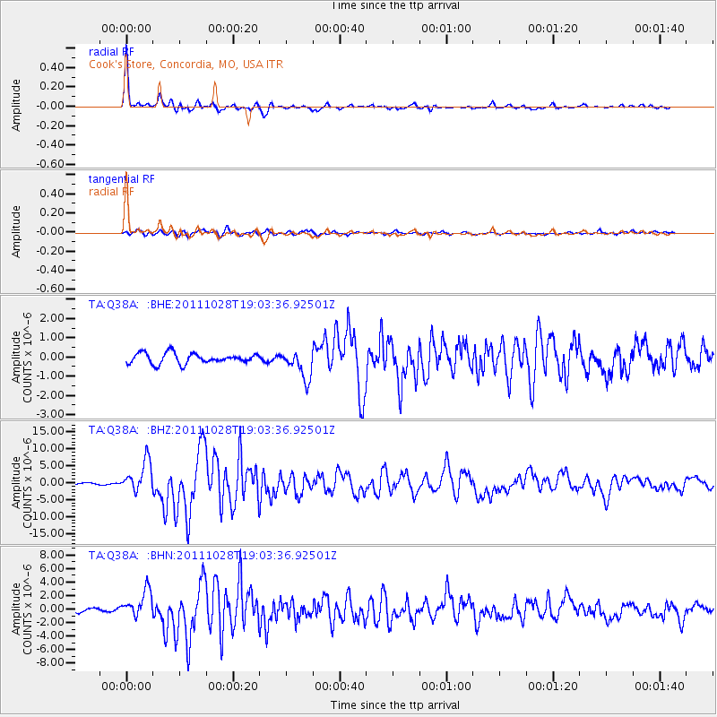
Signal To Noise
| Channel | StoN | STA | LTA |
| TA:Q38A: :BHZ:20111028T19:03:36.92501Z | 18.955488 | 4.638204E-6 | 2.4468923E-7 |
| TA:Q38A: :BHN:20111028T19:03:36.92501Z | 8.118529 | 1.9940874E-6 | 2.4562178E-7 |
| TA:Q38A: :BHE:20111028T19:03:36.92501Z | 2.8303547 | 7.5532313E-7 | 2.668652E-7 |
| Arrivals |
| Ps | 6.3 SECOND |
| PpPs | 20 SECOND |
| PsPs/PpSs | 26 SECOND |


