You are here: Home > Network List > TA - USArray Transportable Network (new EarthScope stations) Stations List
> Station Q40A Laux Farm, Auxvasse, MO, USA > Earthquake Result Viewer
Q40A Laux Farm, Auxvasse, MO, USA - Earthquake Result Viewer
| Earthquake location: |
Near Coast Of Peru |
| Earthquake latitude/longitude: |
-14.4/-76.0 |
| Earthquake time(UTC): |
2011/10/28 (301) 18:54:34 GMT |
| Earthquake Depth: |
24 km |
| Earthquake Magnitude: |
6.5 MB, 6.9 MS, 6.9 MW, 6.9 MW |
| Earthquake Catalog/Contributor: |
WHDF/NEIC |
|
| Network: |
TA USArray Transportable Network (new EarthScope stations) |
| Station: |
Q40A Laux Farm, Auxvasse, MO, USA |
| Lat/Lon: |
38.99 N/92.07 W |
| Elevation: |
275 m |
|
| Distance: |
55.2 deg |
| Az: |
344.742 deg |
| Baz: |
160.903 deg |
| Ray Param: |
0.064883776 |
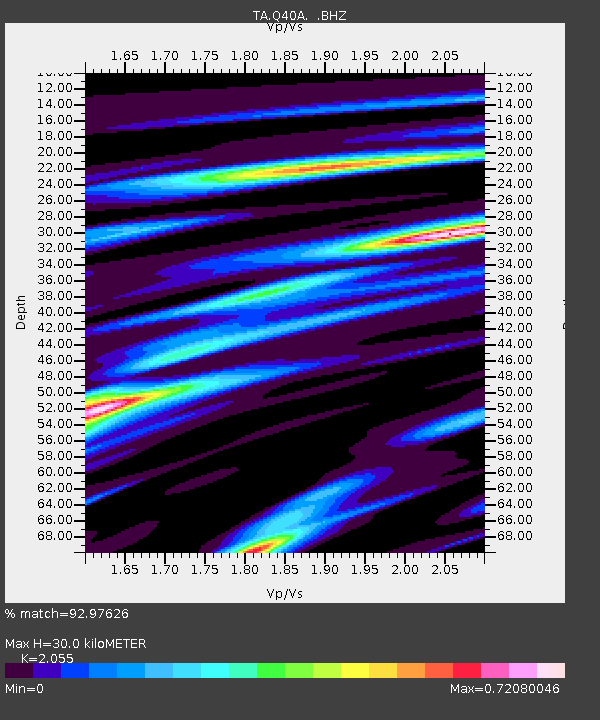
| Estimated Moho Depth: |
30.0 km |
| Estimated Crust Vp/Vs: |
2.06 |
| Assumed Crust Vp: |
6.498 km/s |
| Estimated Crust Vs: |
3.162 km/s |
| Estimated Crust Poisson's Ratio: |
0.34 |
|
| Radial Match: |
92.97626 % |
| Radial Bump: |
286 |
| Transverse Match: |
74.518524 % |
| Transverse Bump: |
400 |
| SOD ConfigId: |
424168 |
| Insert Time: |
2012-02-16 11:01:57.629 +0000 |
| GWidth: |
2.5 |
| Max Bumps: |
400 |
| Tol: |
0.001 |
|
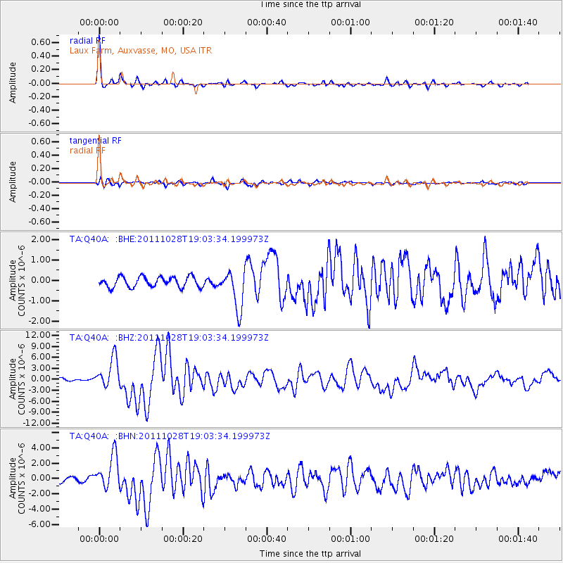
Signal To Noise
| Channel | StoN | STA | LTA |
| TA:Q40A: :BHZ:20111028T19:03:34.199973Z | 13.947626 | 4.219246E-6 | 3.0250638E-7 |
| TA:Q40A: :BHN:20111028T19:03:34.199973Z | 8.973451 | 2.2492231E-6 | 2.506531E-7 |
| TA:Q40A: :BHE:20111028T19:03:34.199973Z | 3.8529427 | 9.85851E-7 | 2.5586962E-7 |
| Arrivals |
| Ps | 5.1 SECOND |
| PpPs | 13 SECOND |
| PsPs/PpSs | 19 SECOND |


