You are here: Home > Network List > TA - USArray Transportable Network (new EarthScope stations) Stations List
> Station O39A Kirksville, MO, USA > Earthquake Result Viewer
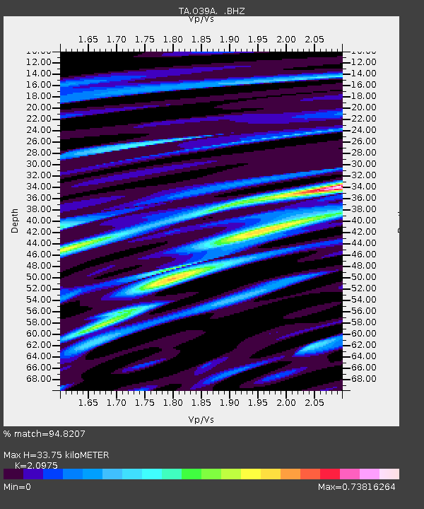
O39A Kirksville, MO, USA - Earthquake Result Viewer
| Earthquake location: |
Near Coast Of Peru |
| Earthquake latitude/longitude: |
-14.4/-76.0 |
| Earthquake time(UTC): |
2011/10/28 (301) 18:54:34 GMT |
| Earthquake Depth: |
24 km |
| Earthquake Magnitude: |
6.5 MB, 6.9 MS, 6.9 MW, 6.9 MW |
| Earthquake Catalog/Contributor: |
WHDF/NEIC |
|
| Network: |
TA USArray Transportable Network (new EarthScope stations) |
| Station: |
O39A Kirksville, MO, USA |
| Lat/Lon: |
40.25 N/92.54 W |
| Elevation: |
282 m |
|
| Distance: |
56.6 deg |
| Az: |
344.829 deg |
| Baz: |
160.653 deg |
| Ray Param: |
0.06403228 |
| Estimated Moho Depth: |
33.75 km |
| Estimated Crust Vp/Vs: |
2.10 |
| Assumed Crust Vp: |
6.498 km/s |
| Estimated Crust Vs: |
3.098 km/s |
| Estimated Crust Poisson's Ratio: |
0.35 |
|
| Radial Match: |
94.8207 % |
| Radial Bump: |
400 |
| Transverse Match: |
79.90758 % |
| Transverse Bump: |
400 |
| SOD ConfigId: |
424168 |
| Insert Time: |
2012-02-16 11:02:09.137 +0000 |
| GWidth: |
2.5 |
| Max Bumps: |
400 |
| Tol: |
0.001 |
|

Signal To Noise
| Channel | StoN | STA | LTA |
| TA:O39A: :BHZ:20111028T19:03:43.55001Z | 12.558674 | 4.282131E-6 | 3.4097002E-7 |
| TA:O39A: :BHN:20111028T19:03:43.55001Z | 5.4555664 | 2.2042989E-6 | 4.0404584E-7 |
| TA:O39A: :BHE:20111028T19:03:43.55001Z | 3.1870668 | 8.376792E-7 | 2.6283703E-7 |
| Arrivals |
| Ps | 6.0 SECOND |
| PpPs | 15 SECOND |
| PsPs/PpSs | 21 SECOND |


