You are here: Home > Network List > TA - USArray Transportable Network (new EarthScope stations) Stations List
> Station R40A Maddie's Station, St. Elizabeth, MO, USA > Earthquake Result Viewer
R40A Maddie's Station, St. Elizabeth, MO, USA - Earthquake Result Viewer
| Earthquake location: |
Near Coast Of Peru |
| Earthquake latitude/longitude: |
-14.4/-76.0 |
| Earthquake time(UTC): |
2011/10/28 (301) 18:54:34 GMT |
| Earthquake Depth: |
24 km |
| Earthquake Magnitude: |
6.5 MB, 6.9 MS, 6.9 MW, 6.9 MW |
| Earthquake Catalog/Contributor: |
WHDF/NEIC |
|
| Network: |
TA USArray Transportable Network (new EarthScope stations) |
| Station: |
R40A Maddie's Station, St. Elizabeth, MO, USA |
| Lat/Lon: |
38.29 N/92.27 W |
| Elevation: |
213 m |
|
| Distance: |
54.6 deg |
| Az: |
344.284 deg |
| Baz: |
160.519 deg |
| Ray Param: |
0.06529257 |
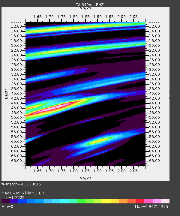
| Estimated Moho Depth: |
45.5 km |
| Estimated Crust Vp/Vs: |
1.72 |
| Assumed Crust Vp: |
6.498 km/s |
| Estimated Crust Vs: |
3.772 km/s |
| Estimated Crust Poisson's Ratio: |
0.25 |
|
| Radial Match: |
93.130615 % |
| Radial Bump: |
324 |
| Transverse Match: |
75.69405 % |
| Transverse Bump: |
400 |
| SOD ConfigId: |
424168 |
| Insert Time: |
2012-02-16 11:02:21.052 +0000 |
| GWidth: |
2.5 |
| Max Bumps: |
400 |
| Tol: |
0.001 |
|

Signal To Noise
| Channel | StoN | STA | LTA |
| TA:R40A: :BHZ:20111028T19:03:29.774985Z | 11.065067 | 3.0961796E-6 | 2.798157E-7 |
| TA:R40A: :BHN:20111028T19:03:29.774985Z | 5.079708 | 1.5244125E-6 | 3.0009843E-7 |
| TA:R40A: :BHE:20111028T19:03:29.774985Z | 3.9139924 | 9.1364114E-7 | 2.3342946E-7 |
| Arrivals |
| Ps | 5.3 SECOND |
| PpPs | 18 SECOND |
| PsPs/PpSs | 23 SECOND |


