You are here: Home > Network List > TA - USArray Transportable Network (new EarthScope stations) Stations List
> Station S38A Stockton, MO, USA > Earthquake Result Viewer
S38A Stockton, MO, USA - Earthquake Result Viewer
| Earthquake location: |
Near Coast Of Peru |
| Earthquake latitude/longitude: |
-14.4/-76.0 |
| Earthquake time(UTC): |
2011/10/28 (301) 18:54:34 GMT |
| Earthquake Depth: |
24 km |
| Earthquake Magnitude: |
6.5 MB, 6.9 MS, 6.9 MW, 6.9 MW |
| Earthquake Catalog/Contributor: |
WHDF/NEIC |
|
| Network: |
TA USArray Transportable Network (new EarthScope stations) |
| Station: |
S38A Stockton, MO, USA |
| Lat/Lon: |
37.63 N/93.91 W |
| Elevation: |
294 m |
|
| Distance: |
54.5 deg |
| Az: |
342.51 deg |
| Baz: |
158.486 deg |
| Ray Param: |
0.065394804 |
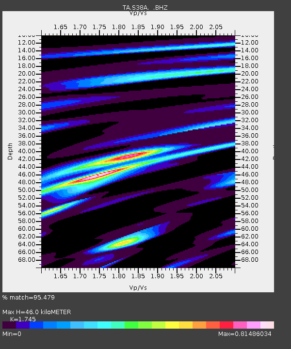
| Estimated Moho Depth: |
46.0 km |
| Estimated Crust Vp/Vs: |
1.75 |
| Assumed Crust Vp: |
6.53 km/s |
| Estimated Crust Vs: |
3.742 km/s |
| Estimated Crust Poisson's Ratio: |
0.26 |
|
| Radial Match: |
95.479 % |
| Radial Bump: |
224 |
| Transverse Match: |
80.22556 % |
| Transverse Bump: |
400 |
| SOD ConfigId: |
424168 |
| Insert Time: |
2012-02-16 11:02:55.782 +0000 |
| GWidth: |
2.5 |
| Max Bumps: |
400 |
| Tol: |
0.001 |
|

Signal To Noise
| Channel | StoN | STA | LTA |
| TA:S38A: :BHZ:20111028T19:03:28.599998Z | 11.237511 | 3.3683823E-6 | 2.9974453E-7 |
| TA:S38A: :BHN:20111028T19:03:28.599998Z | 5.737666 | 1.6463117E-6 | 2.8693054E-7 |
| TA:S38A: :BHE:20111028T19:03:28.599998Z | 2.466179 | 5.8085476E-7 | 2.3552823E-7 |
| Arrivals |
| Ps | 5.5 SECOND |
| PpPs | 18 SECOND |
| PsPs/PpSs | 24 SECOND |


