You are here: Home > Network List > TA - USArray Transportable Network (new EarthScope stations) Stations List
> Station T39A Clever, MO, USA > Earthquake Result Viewer
T39A Clever, MO, USA - Earthquake Result Viewer
| Earthquake location: |
Near Coast Of Peru |
| Earthquake latitude/longitude: |
-14.4/-76.0 |
| Earthquake time(UTC): |
2011/10/28 (301) 18:54:34 GMT |
| Earthquake Depth: |
24 km |
| Earthquake Magnitude: |
6.5 MB, 6.9 MS, 6.9 MW, 6.9 MW |
| Earthquake Catalog/Contributor: |
WHDF/NEIC |
|
| Network: |
TA USArray Transportable Network (new EarthScope stations) |
| Station: |
T39A Clever, MO, USA |
| Lat/Lon: |
37.02 N/93.38 W |
| Elevation: |
366 m |
|
| Distance: |
53.8 deg |
| Az: |
342.725 deg |
| Baz: |
158.932 deg |
| Ray Param: |
0.065853134 |
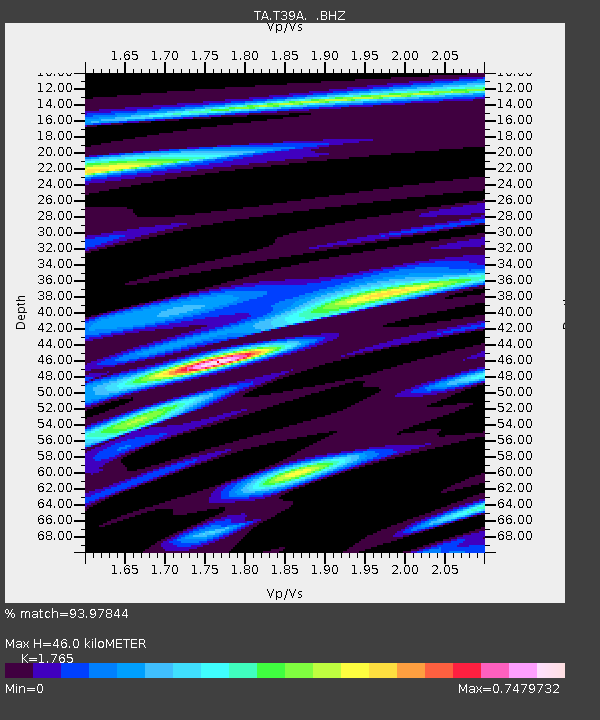
| Estimated Moho Depth: |
46.0 km |
| Estimated Crust Vp/Vs: |
1.76 |
| Assumed Crust Vp: |
6.53 km/s |
| Estimated Crust Vs: |
3.7 km/s |
| Estimated Crust Poisson's Ratio: |
0.26 |
|
| Radial Match: |
93.97844 % |
| Radial Bump: |
299 |
| Transverse Match: |
74.65839 % |
| Transverse Bump: |
400 |
| SOD ConfigId: |
424168 |
| Insert Time: |
2012-02-16 11:02:57.294 +0000 |
| GWidth: |
2.5 |
| Max Bumps: |
400 |
| Tol: |
0.001 |
|
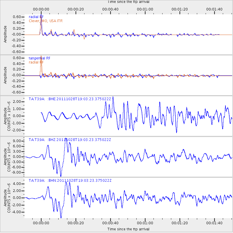
Signal To Noise
| Channel | StoN | STA | LTA |
| TA:T39A: :BHZ:20111028T19:03:23.375022Z | 9.997766 | 3.0979181E-6 | 3.0986104E-7 |
| TA:T39A: :BHN:20111028T19:03:23.375022Z | 4.849742 | 1.4775318E-6 | 3.046619E-7 |
| TA:T39A: :BHE:20111028T19:03:23.375022Z | 2.378915 | 7.564673E-7 | 3.1798834E-7 |
| Arrivals |
| Ps | 5.7 SECOND |
| PpPs | 18 SECOND |
| PsPs/PpSs | 24 SECOND |


