You are here: Home > Network List > TA - USArray Transportable Network (new EarthScope stations) Stations List
> Station X40A Basin Creek Farm, Marlvern, AR, USA > Earthquake Result Viewer
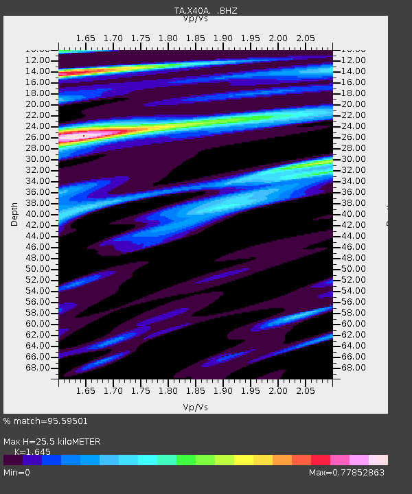
X40A Basin Creek Farm, Marlvern, AR, USA - Earthquake Result Viewer
| Earthquake location: |
Near Coast Of Peru |
| Earthquake latitude/longitude: |
-14.4/-76.0 |
| Earthquake time(UTC): |
2011/10/28 (301) 18:54:34 GMT |
| Earthquake Depth: |
24 km |
| Earthquake Magnitude: |
6.5 MB, 6.9 MS, 6.9 MW, 6.9 MW |
| Earthquake Catalog/Contributor: |
WHDF/NEIC |
|
| Network: |
TA USArray Transportable Network (new EarthScope stations) |
| Station: |
X40A Basin Creek Farm, Marlvern, AR, USA |
| Lat/Lon: |
34.49 N/92.83 W |
| Elevation: |
158 m |
|
| Distance: |
51.2 deg |
| Az: |
342.096 deg |
| Baz: |
158.865 deg |
| Ray Param: |
0.06750875 |
| Estimated Moho Depth: |
25.5 km |
| Estimated Crust Vp/Vs: |
1.64 |
| Assumed Crust Vp: |
6.498 km/s |
| Estimated Crust Vs: |
3.95 km/s |
| Estimated Crust Poisson's Ratio: |
0.21 |
|
| Radial Match: |
95.59501 % |
| Radial Bump: |
388 |
| Transverse Match: |
82.99881 % |
| Transverse Bump: |
400 |
| SOD ConfigId: |
424168 |
| Insert Time: |
2012-02-16 11:03:12.420 +0000 |
| GWidth: |
2.5 |
| Max Bumps: |
400 |
| Tol: |
0.001 |
|

Signal To Noise
| Channel | StoN | STA | LTA |
| TA:X40A: :BHZ:20111028T19:03:04.724998Z | 17.233139 | 3.3602696E-6 | 1.9498883E-7 |
| TA:X40A: :BHN:20111028T19:03:04.724998Z | 5.9567027 | 1.2550181E-6 | 2.1069008E-7 |
| TA:X40A: :BHE:20111028T19:03:04.724998Z | 4.506264 | 6.843529E-7 | 1.5186703E-7 |
| Arrivals |
| Ps | 2.7 SECOND |
| PpPs | 9.7 SECOND |
| PsPs/PpSs | 12 SECOND |


