You are here: Home > Network List > TA - USArray Transportable Network (new EarthScope stations) Stations List
> Station X39A Fountain Ranch, Mena, AR, USA > Earthquake Result Viewer
X39A Fountain Ranch, Mena, AR, USA - Earthquake Result Viewer
| Earthquake location: |
Near Coast Of Peru |
| Earthquake latitude/longitude: |
-14.4/-76.0 |
| Earthquake time(UTC): |
2011/10/28 (301) 18:54:34 GMT |
| Earthquake Depth: |
24 km |
| Earthquake Magnitude: |
6.5 MB, 6.9 MS, 6.9 MW, 6.9 MW |
| Earthquake Catalog/Contributor: |
WHDF/NEIC |
|
| Network: |
TA USArray Transportable Network (new EarthScope stations) |
| Station: |
X39A Fountain Ranch, Mena, AR, USA |
| Lat/Lon: |
34.51 N/94.11 W |
| Elevation: |
326 m |
|
| Distance: |
51.6 deg |
| Az: |
340.853 deg |
| Baz: |
157.369 deg |
| Ray Param: |
0.0672409 |
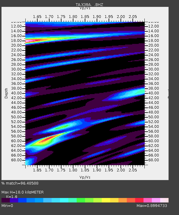
| Estimated Moho Depth: |
18.0 km |
| Estimated Crust Vp/Vs: |
1.60 |
| Assumed Crust Vp: |
6.498 km/s |
| Estimated Crust Vs: |
4.061 km/s |
| Estimated Crust Poisson's Ratio: |
0.18 |
|
| Radial Match: |
96.48588 % |
| Radial Bump: |
256 |
| Transverse Match: |
90.96956 % |
| Transverse Bump: |
396 |
| SOD ConfigId: |
424168 |
| Insert Time: |
2012-02-16 11:03:21.484 +0000 |
| GWidth: |
2.5 |
| Max Bumps: |
400 |
| Tol: |
0.001 |
|

Signal To Noise
| Channel | StoN | STA | LTA |
| TA:X39A: :BHZ:20111028T19:03:07.824973Z | 12.223784 | 3.0267367E-6 | 2.4761044E-7 |
| TA:X39A: :BHN:20111028T19:03:07.824973Z | 6.90795 | 1.2016604E-6 | 1.7395325E-7 |
| TA:X39A: :BHE:20111028T19:03:07.824973Z | 3.885005 | 6.0468574E-7 | 1.5564606E-7 |
| Arrivals |
| Ps | 1.8 SECOND |
| PpPs | 6.8 SECOND |
| PsPs/PpSs | 8.5 SECOND |


