You are here: Home > Network List > TA - USArray Transportable Network (new EarthScope stations) Stations List
> Station 143A Socs Landing, Pioneer, LA, USA > Earthquake Result Viewer
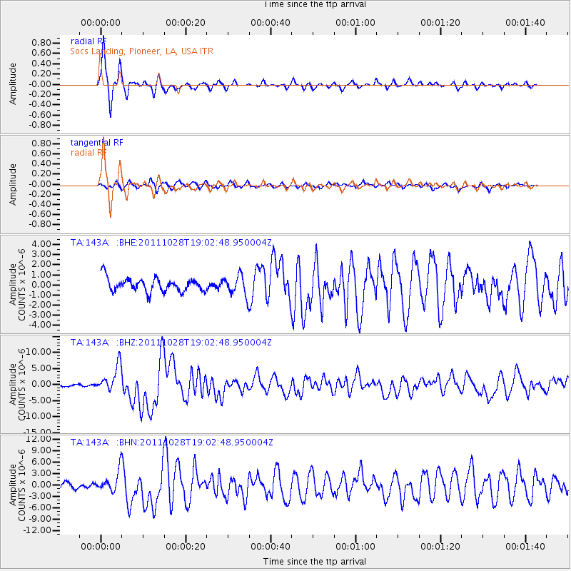
143A Socs Landing, Pioneer, LA, USA - Earthquake Result Viewer
| Earthquake location: |
Near Coast Of Peru |
| Earthquake latitude/longitude: |
-14.4/-76.0 |
| Earthquake time(UTC): |
2011/10/28 (301) 18:54:34 GMT |
| Earthquake Depth: |
24 km |
| Earthquake Magnitude: |
6.5 MB, 6.9 MS, 6.9 MW, 6.9 MW |
| Earthquake Catalog/Contributor: |
WHDF/NEIC |
|
| Network: |
TA USArray Transportable Network (new EarthScope stations) |
| Station: |
143A Socs Landing, Pioneer, LA, USA |
| Lat/Lon: |
32.70 N/91.40 W |
| Elevation: |
30 m |
|
| Distance: |
49.1 deg |
| Az: |
342.739 deg |
| Baz: |
160.065 deg |
| Ray Param: |
0.06885035 |
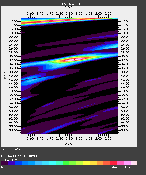
| Estimated Moho Depth: |
31.25 km |
| Estimated Crust Vp/Vs: |
1.88 |
| Assumed Crust Vp: |
6.201 km/s |
| Estimated Crust Vs: |
3.307 km/s |
| Estimated Crust Poisson's Ratio: |
0.30 |
|
| Radial Match: |
94.86681 % |
| Radial Bump: |
262 |
| Transverse Match: |
81.527794 % |
| Transverse Bump: |
400 |
| SOD ConfigId: |
424168 |
| Insert Time: |
2012-02-16 11:04:23.815 +0000 |
| GWidth: |
2.5 |
| Max Bumps: |
400 |
| Tol: |
0.001 |
|
Signal To Noise
| Channel | StoN | STA | LTA |
| TA:143A: :BHZ:20111028T19:02:48.950004Z | 20.231268 | 4.2151833E-6 | 2.0834993E-7 |
| TA:143A: :BHN:20111028T19:02:48.950004Z | 3.6461031 | 2.7224567E-6 | 7.4667577E-7 |
| TA:143A: :BHE:20111028T19:02:48.950004Z | 1.5479202 | 1.032724E-6 | 6.671687E-7 |
| Arrivals |
| Ps | 4.6 SECOND |
| PpPs | 14 SECOND |
| PsPs/PpSs | 18 SECOND |


