You are here: Home > Network List > TA - USArray Transportable Network (new EarthScope stations) Stations List
> Station V40A Witts Springs, AR, USA > Earthquake Result Viewer
V40A Witts Springs, AR, USA - Earthquake Result Viewer

| Earthquake location: |
Near Coast Of Peru |
| Earthquake latitude/longitude: |
-14.4/-76.0 |
| Earthquake time(UTC): |
2011/10/28 (301) 18:54:34 GMT |
| Earthquake Depth: |
24 km |
| Earthquake Magnitude: |
6.5 MB, 6.9 MS, 6.9 MW, 6.9 MW |
| Earthquake Catalog/Contributor: |
WHDF/NEIC |
|
| Network: |
TA USArray Transportable Network (new EarthScope stations) |
| Station: |
V40A Witts Springs, AR, USA |
| Lat/Lon: |
35.80 N/92.82 W |
| Elevation: |
570 m |
|
| Distance: |
52.5 deg |
| Az: |
342.704 deg |
| Baz: |
159.247 deg |
| Ray Param: |
0.066713154 |
| Estimated Moho Depth: |
28.75 km |
| Estimated Crust Vp/Vs: |
2.10 |
| Assumed Crust Vp: |
6.498 km/s |
| Estimated Crust Vs: |
3.098 km/s |
| Estimated Crust Poisson's Ratio: |
0.35 |
|
| Radial Match: |
96.38065 % |
| Radial Bump: |
329 |
| Transverse Match: |
82.13767 % |
| Transverse Bump: |
400 |
| SOD ConfigId: |
424168 |
| Insert Time: |
2012-02-16 11:04:57.722 +0000 |
| GWidth: |
2.5 |
| Max Bumps: |
400 |
| Tol: |
0.001 |
|
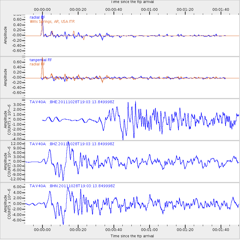
Signal To Noise
| Channel | StoN | STA | LTA |
| TA:V40A: :BHZ:20111028T19:03:13.849998Z | 16.217405 | 3.6751935E-6 | 2.2662032E-7 |
| TA:V40A: :BHN:20111028T19:03:13.849998Z | 11.164543 | 1.9779773E-6 | 1.7716597E-7 |
| TA:V40A: :BHE:20111028T19:03:13.849998Z | 3.5128117 | 8.995446E-7 | 2.5607537E-7 |
| Arrivals |
| Ps | 5.1 SECOND |
| PpPs | 13 SECOND |
| PsPs/PpSs | 18 SECOND |


