You are here: Home > Network List > TA - USArray Transportable Network (new EarthScope stations) Stations List
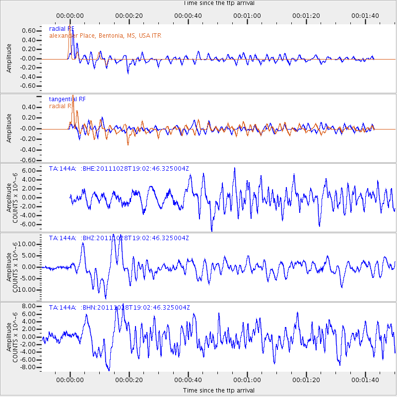
> Station 144A alexander Place, Bentonia, MS, USA > Earthquake Result Viewer
144A alexander Place, Bentonia, MS, USA - Earthquake Result Viewer
| Earthquake location: |
Near Coast Of Peru |
| Earthquake latitude/longitude: |
-14.4/-76.0 |
| Earthquake time(UTC): |
2011/10/28 (301) 18:54:34 GMT |
| Earthquake Depth: |
24 km |
| Earthquake Magnitude: |
6.5 MB, 6.9 MS, 6.9 MW, 6.9 MW |
| Earthquake Catalog/Contributor: |
WHDF/NEIC |
|
| Network: |
TA USArray Transportable Network (new EarthScope stations) |
| Station: |
144A alexander Place, Bentonia, MS, USA |
| Lat/Lon: |
32.63 N/90.42 W |
| Elevation: |
78 m |
|
| Distance: |
48.8 deg |
| Az: |
343.742 deg |
| Baz: |
161.25 deg |
| Ray Param: |
0.06907936 |
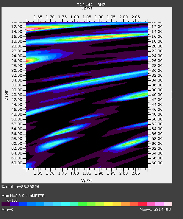
| Estimated Moho Depth: |
13.0 km |
| Estimated Crust Vp/Vs: |
1.60 |
| Assumed Crust Vp: |
6.201 km/s |
| Estimated Crust Vs: |
3.876 km/s |
| Estimated Crust Poisson's Ratio: |
0.18 |
|
| Radial Match: |
88.35526 % |
| Radial Bump: |
400 |
| Transverse Match: |
63.52747 % |
| Transverse Bump: |
400 |
| SOD ConfigId: |
424168 |
| Insert Time: |
2012-02-16 11:05:39.192 +0000 |
| GWidth: |
2.5 |
| Max Bumps: |
400 |
| Tol: |
0.001 |
|
Signal To Noise
| Channel | StoN | STA | LTA |
| TA:144A: :BHZ:20111028T19:02:46.325004Z | 11.870036 | 4.432778E-6 | 3.7344265E-7 |
| TA:144A: :BHN:20111028T19:02:46.325004Z | 1.6200334 | 1.3213186E-6 | 8.1561194E-7 |
| TA:144A: :BHE:20111028T19:02:46.325004Z | 1.0667802 | 1.202067E-6 | 1.1268179E-6 |
| Arrivals |
| Ps | 1.3 SECOND |
| PpPs | 5.1 SECOND |
| PsPs/PpSs | 6.5 SECOND |


