You are here: Home > Network List > TA - USArray Transportable Network (new EarthScope stations) Stations List
> Station Z43A Armstrong Family, Eudora, AR, USA > Earthquake Result Viewer
Z43A Armstrong Family, Eudora, AR, USA - Earthquake Result Viewer
| Earthquake location: |
Near Coast Of Peru |
| Earthquake latitude/longitude: |
-14.4/-76.0 |
| Earthquake time(UTC): |
2011/10/28 (301) 18:54:34 GMT |
| Earthquake Depth: |
24 km |
| Earthquake Magnitude: |
6.5 MB, 6.9 MS, 6.9 MW, 6.9 MW |
| Earthquake Catalog/Contributor: |
WHDF/NEIC |
|
| Network: |
TA USArray Transportable Network (new EarthScope stations) |
| Station: |
Z43A Armstrong Family, Eudora, AR, USA |
| Lat/Lon: |
33.21 N/91.24 W |
| Elevation: |
39 m |
|
| Distance: |
49.6 deg |
| Az: |
343.131 deg |
| Baz: |
160.406 deg |
| Ray Param: |
0.06857622 |
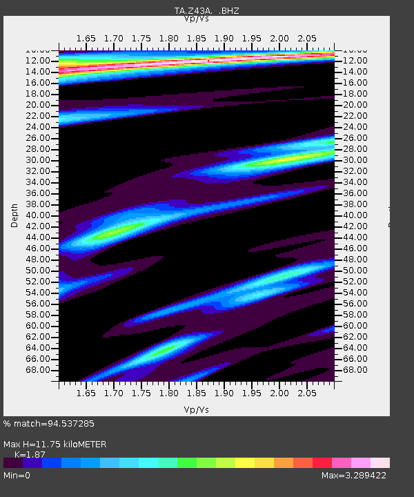
| Estimated Moho Depth: |
11.75 km |
| Estimated Crust Vp/Vs: |
1.87 |
| Assumed Crust Vp: |
6.201 km/s |
| Estimated Crust Vs: |
3.316 km/s |
| Estimated Crust Poisson's Ratio: |
0.30 |
|
| Radial Match: |
94.537285 % |
| Radial Bump: |
297 |
| Transverse Match: |
90.20562 % |
| Transverse Bump: |
343 |
| SOD ConfigId: |
424168 |
| Insert Time: |
2012-02-16 11:07:10.912 +0000 |
| GWidth: |
2.5 |
| Max Bumps: |
400 |
| Tol: |
0.001 |
|
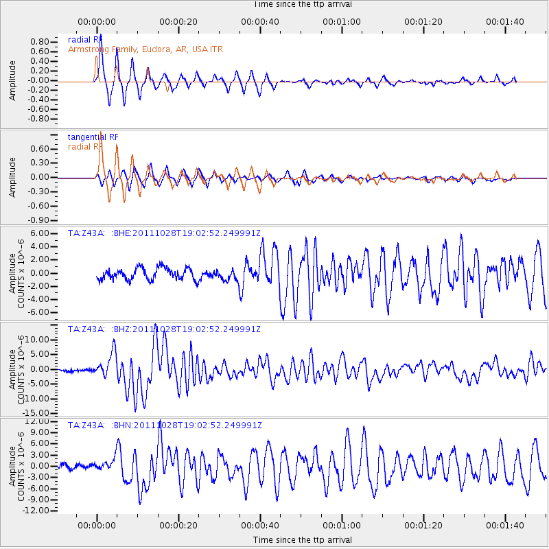
Signal To Noise
| Channel | StoN | STA | LTA |
| TA:Z43A: :BHZ:20111028T19:02:52.249991Z | 10.958654 | 4.329471E-6 | 3.950732E-7 |
| TA:Z43A: :BHN:20111028T19:02:52.249991Z | 2.1753948 | 1.7816704E-6 | 8.190102E-7 |
| TA:Z43A: :BHE:20111028T19:02:52.249991Z | 0.97321576 | 8.4457594E-7 | 8.6781984E-7 |
| Arrivals |
| Ps | 1.7 SECOND |
| PpPs | 5.2 SECOND |
| PsPs/PpSs | 6.9 SECOND |


