You are here: Home > Network List > TA - USArray Transportable Network (new EarthScope stations) Stations List
> Station W44A Shelby Farms Park, Memphis, TN, USA > Earthquake Result Viewer
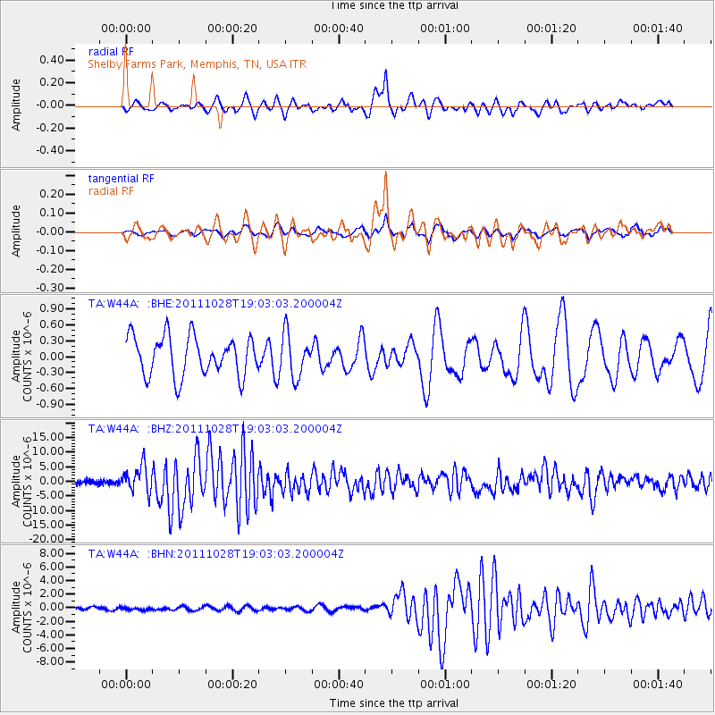
W44A Shelby Farms Park, Memphis, TN, USA - Earthquake Result Viewer
*The percent match for this event was below the threshold and hence no stack was calculated.
| Earthquake location: |
Near Coast Of Peru |
| Earthquake latitude/longitude: |
-14.4/-76.0 |
| Earthquake time(UTC): |
2011/10/28 (301) 18:54:34 GMT |
| Earthquake Depth: |
24 km |
| Earthquake Magnitude: |
6.5 MB, 6.9 MS, 6.9 MW, 6.9 MW |
| Earthquake Catalog/Contributor: |
WHDF/NEIC |
|
| Network: |
TA USArray Transportable Network (new EarthScope stations) |
| Station: |
W44A Shelby Farms Park, Memphis, TN, USA |
| Lat/Lon: |
35.14 N/89.82 W |
| Elevation: |
101 m |
|
| Distance: |
51.0 deg |
| Az: |
345.383 deg |
| Baz: |
162.644 deg |
| Ray Param: |
$rayparam |
*The percent match for this event was below the threshold and hence was not used in the summary stack. |
|
| Radial Match: |
70.87748 % |
| Radial Bump: |
400 |
| Transverse Match: |
56.335606 % |
| Transverse Bump: |
400 |
| SOD ConfigId: |
424168 |
| Insert Time: |
2012-02-16 11:08:01.404 +0000 |
| GWidth: |
2.5 |
| Max Bumps: |
400 |
| Tol: |
0.001 |
|
Signal To Noise
| Channel | StoN | STA | LTA |
| TA:W44A: :BHZ:20111028T19:03:03.200004Z | 7.172464 | 4.519856E-6 | 6.301678E-7 |
| TA:W44A: :BHN:20111028T19:03:03.200004Z | 0.4422766 | 1.8838738E-7 | 4.2594922E-7 |
| TA:W44A: :BHE:20111028T19:03:03.200004Z | 1.0924404 | 4.058483E-7 | 3.7150613E-7 |
| Arrivals |
| Ps | |
| PpPs | |
| PsPs/PpSs | |


