You are here: Home > Network List > TA - USArray Transportable Network (new EarthScope stations) Stations List
> Station R44A Waltonville, IL, USA > Earthquake Result Viewer
R44A Waltonville, IL, USA - Earthquake Result Viewer
| Earthquake location: |
Near Coast Of Peru |
| Earthquake latitude/longitude: |
-14.4/-76.0 |
| Earthquake time(UTC): |
2011/10/28 (301) 18:54:34 GMT |
| Earthquake Depth: |
24 km |
| Earthquake Magnitude: |
6.5 MB, 6.9 MS, 6.9 MW, 6.9 MW |
| Earthquake Catalog/Contributor: |
WHDF/NEIC |
|
| Network: |
TA USArray Transportable Network (new EarthScope stations) |
| Station: |
R44A Waltonville, IL, USA |
| Lat/Lon: |
38.25 N/89.08 W |
| Elevation: |
144 m |
|
| Distance: |
53.8 deg |
| Az: |
347.214 deg |
| Baz: |
164.198 deg |
| Ray Param: |
0.06579988 |
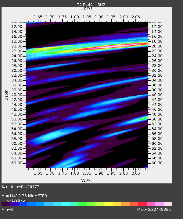
| Estimated Moho Depth: |
19.75 km |
| Estimated Crust Vp/Vs: |
1.97 |
| Assumed Crust Vp: |
6.444 km/s |
| Estimated Crust Vs: |
3.275 km/s |
| Estimated Crust Poisson's Ratio: |
0.33 |
|
| Radial Match: |
94.26477 % |
| Radial Bump: |
291 |
| Transverse Match: |
88.45699 % |
| Transverse Bump: |
400 |
| SOD ConfigId: |
424168 |
| Insert Time: |
2012-02-16 11:08:41.744 +0000 |
| GWidth: |
2.5 |
| Max Bumps: |
400 |
| Tol: |
0.001 |
|

Signal To Noise
| Channel | StoN | STA | LTA |
| TA:R44A: :BHZ:20111028T19:03:23.949973Z | 13.496453 | 4.197513E-6 | 3.1100862E-7 |
| TA:R44A: :BHN:20111028T19:03:23.949973Z | 5.1389203 | 2.3197342E-6 | 4.5140501E-7 |
| TA:R44A: :BHE:20111028T19:03:23.949973Z | 3.1238835 | 7.458579E-7 | 2.3875984E-7 |
| Arrivals |
| Ps | 3.1 SECOND |
| PpPs | 8.7 SECOND |
| PsPs/PpSs | 12 SECOND |


