You are here: Home > Network List > TA - USArray Transportable Network (new EarthScope stations) Stations List
> Station T44A Benton, MO, USA > Earthquake Result Viewer
T44A Benton, MO, USA - Earthquake Result Viewer
| Earthquake location: |
Near Coast Of Peru |
| Earthquake latitude/longitude: |
-14.4/-76.0 |
| Earthquake time(UTC): |
2011/10/28 (301) 18:54:34 GMT |
| Earthquake Depth: |
24 km |
| Earthquake Magnitude: |
6.5 MB, 6.9 MS, 6.9 MW, 6.9 MW |
| Earthquake Catalog/Contributor: |
WHDF/NEIC |
|
| Network: |
TA USArray Transportable Network (new EarthScope stations) |
| Station: |
T44A Benton, MO, USA |
| Lat/Lon: |
37.09 N/89.59 W |
| Elevation: |
133 m |
|
| Distance: |
52.8 deg |
| Az: |
346.327 deg |
| Baz: |
163.359 deg |
| Ray Param: |
0.06647038 |
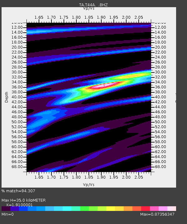
| Estimated Moho Depth: |
35.0 km |
| Estimated Crust Vp/Vs: |
1.91 |
| Assumed Crust Vp: |
6.444 km/s |
| Estimated Crust Vs: |
3.374 km/s |
| Estimated Crust Poisson's Ratio: |
0.31 |
|
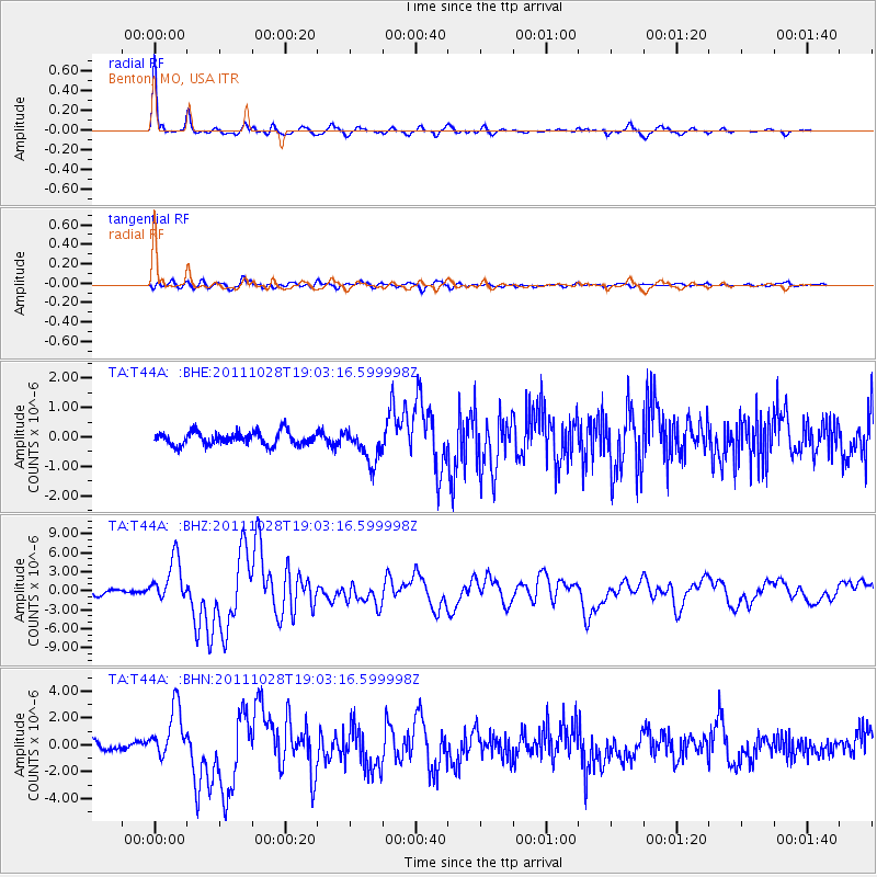
| Radial Match: |
94.307 % |
| Radial Bump: |
295 |
| Transverse Match: |
82.337 % |
| Transverse Bump: |
400 |
| SOD ConfigId: |
424168 |
| Insert Time: |
2012-02-16 11:10:27.187 +0000 |
| GWidth: |
2.5 |
| Max Bumps: |
400 |
| Tol: |
0.001 |
|
Signal To Noise
| Channel | StoN | STA | LTA |
| TA:T44A: :BHZ:20111028T19:03:16.599998Z | 10.889348 | 3.4413904E-6 | 3.1603275E-7 |
| TA:T44A: :BHN:20111028T19:03:16.599998Z | 6.251643 | 1.92483E-6 | 3.0789187E-7 |
| TA:T44A: :BHE:20111028T19:03:16.599998Z | 2.6083581 | 5.794044E-7 | 2.2213376E-7 |
| Arrivals |
| Ps | 5.2 SECOND |
| PpPs | 15 SECOND |
| PsPs/PpSs | 20 SECOND |


