You are here: Home > Network List > TA - USArray Transportable Network (new EarthScope stations) Stations List
> Station U43A Rector, AR, USA > Earthquake Result Viewer
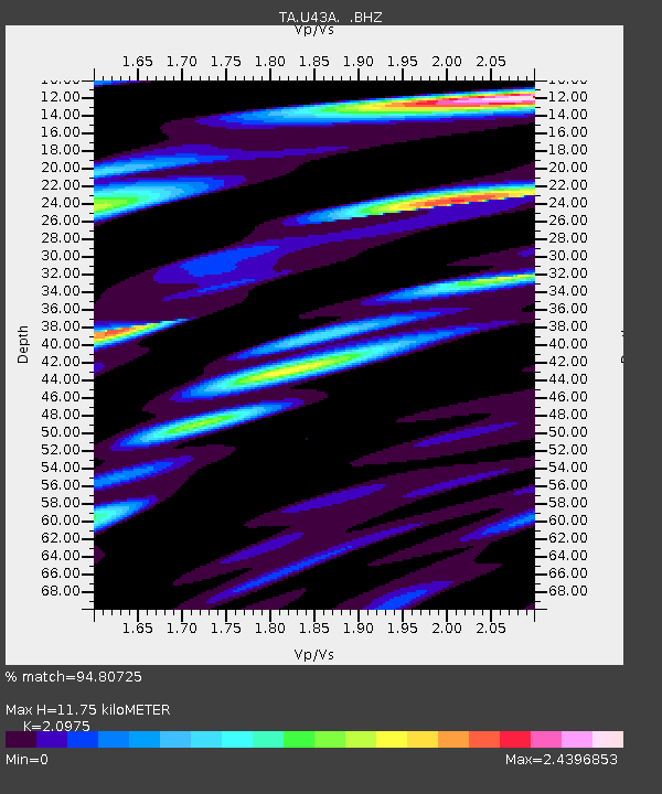
U43A Rector, AR, USA - Earthquake Result Viewer
| Earthquake location: |
Near Coast Of Peru |
| Earthquake latitude/longitude: |
-14.4/-76.0 |
| Earthquake time(UTC): |
2011/10/28 (301) 18:54:34 GMT |
| Earthquake Depth: |
24 km |
| Earthquake Magnitude: |
6.5 MB, 6.9 MS, 6.9 MW, 6.9 MW |
| Earthquake Catalog/Contributor: |
WHDF/NEIC |
|
| Network: |
TA USArray Transportable Network (new EarthScope stations) |
| Station: |
U43A Rector, AR, USA |
| Lat/Lon: |
36.37 N/90.41 W |
| Elevation: |
96 m |
|
| Distance: |
52.3 deg |
| Az: |
345.272 deg |
| Baz: |
162.232 deg |
| Ray Param: |
0.06678594 |
| Estimated Moho Depth: |
11.75 km |
| Estimated Crust Vp/Vs: |
2.10 |
| Assumed Crust Vp: |
6.53 km/s |
| Estimated Crust Vs: |
3.113 km/s |
| Estimated Crust Poisson's Ratio: |
0.35 |
|
| Radial Match: |
94.80725 % |
| Radial Bump: |
400 |
| Transverse Match: |
77.01135 % |
| Transverse Bump: |
400 |
| SOD ConfigId: |
424168 |
| Insert Time: |
2012-02-16 11:11:04.536 +0000 |
| GWidth: |
2.5 |
| Max Bumps: |
400 |
| Tol: |
0.001 |
|

Signal To Noise
| Channel | StoN | STA | LTA |
| TA:U43A: :BHZ:20111028T19:03:13.000022Z | 12.631553 | 3.6127608E-6 | 2.8601082E-7 |
| TA:U43A: :BHN:20111028T19:03:13.000022Z | 8.807091 | 2.1781561E-6 | 2.4731844E-7 |
| TA:U43A: :BHE:20111028T19:03:13.000022Z | 3.01047 | 1.2308554E-6 | 4.0885823E-7 |
| Arrivals |
| Ps | 2.1 SECOND |
| PpPs | 5.3 SECOND |
| PsPs/PpSs | 7.4 SECOND |


