You are here: Home > Network List > TA - USArray Transportable Network (new EarthScope stations) Stations List
> Station Q41A Truxton, MO, USA > Earthquake Result Viewer
Q41A Truxton, MO, USA - Earthquake Result Viewer
| Earthquake location: |
Near Coast Of Peru |
| Earthquake latitude/longitude: |
-14.4/-76.0 |
| Earthquake time(UTC): |
2011/10/28 (301) 18:54:34 GMT |
| Earthquake Depth: |
24 km |
| Earthquake Magnitude: |
6.5 MB, 6.9 MS, 6.9 MW, 6.9 MW |
| Earthquake Catalog/Contributor: |
WHDF/NEIC |
|
| Network: |
TA USArray Transportable Network (new EarthScope stations) |
| Station: |
Q41A Truxton, MO, USA |
| Lat/Lon: |
38.95 N/91.23 W |
| Elevation: |
191 m |
|
| Distance: |
55.0 deg |
| Az: |
345.485 deg |
| Baz: |
161.856 deg |
| Ray Param: |
0.06504968 |
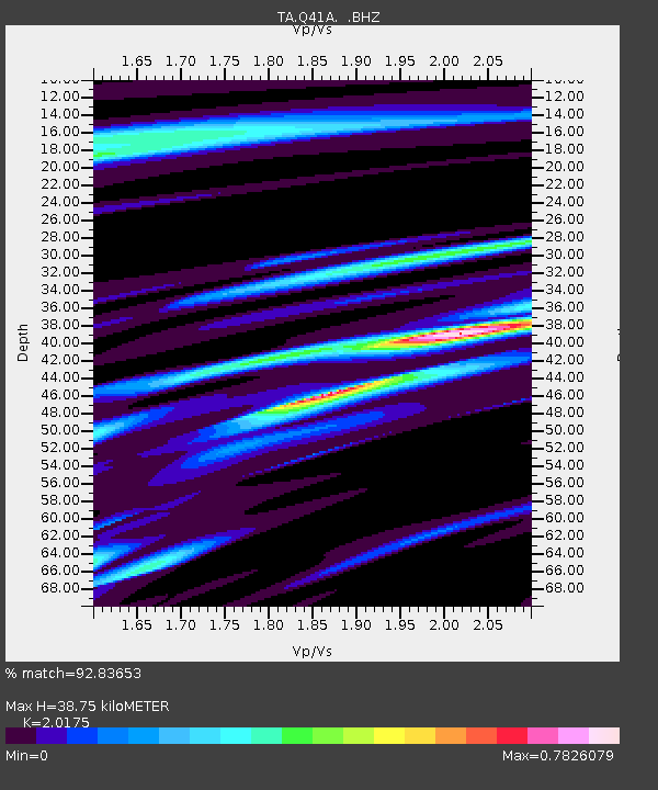
| Estimated Moho Depth: |
38.75 km |
| Estimated Crust Vp/Vs: |
2.02 |
| Assumed Crust Vp: |
6.498 km/s |
| Estimated Crust Vs: |
3.221 km/s |
| Estimated Crust Poisson's Ratio: |
0.34 |
|
| Radial Match: |
92.83653 % |
| Radial Bump: |
340 |
| Transverse Match: |
65.81886 % |
| Transverse Bump: |
400 |
| SOD ConfigId: |
424168 |
| Insert Time: |
2012-02-16 11:12:03.974 +0000 |
| GWidth: |
2.5 |
| Max Bumps: |
400 |
| Tol: |
0.001 |
|

Signal To Noise
| Channel | StoN | STA | LTA |
| TA:Q41A: :BHZ:20111028T19:03:32.399985Z | 8.2523365 | 3.4796883E-6 | 4.2166099E-7 |
| TA:Q41A: :BHN:20111028T19:03:32.399985Z | 4.002381 | 1.747804E-6 | 4.366911E-7 |
| TA:Q41A: :BHE:20111028T19:03:32.399985Z | 1.5166225 | 4.91952E-7 | 3.2437336E-7 |
| Arrivals |
| Ps | 6.4 SECOND |
| PpPs | 17 SECOND |
| PsPs/PpSs | 24 SECOND |


