You are here: Home > Network List > TA - USArray Transportable Network (new EarthScope stations) Stations List
> Station H38A Maiden Rock, WI, USA > Earthquake Result Viewer
H38A Maiden Rock, WI, USA - Earthquake Result Viewer
| Earthquake location: |
Near Coast Of Peru |
| Earthquake latitude/longitude: |
-14.4/-76.0 |
| Earthquake time(UTC): |
2011/10/28 (301) 18:54:34 GMT |
| Earthquake Depth: |
24 km |
| Earthquake Magnitude: |
6.5 MB, 6.9 MS, 6.9 MW, 6.9 MW |
| Earthquake Catalog/Contributor: |
WHDF/NEIC |
|
| Network: |
TA USArray Transportable Network (new EarthScope stations) |
| Station: |
H38A Maiden Rock, WI, USA |
| Lat/Lon: |
44.68 N/92.28 W |
| Elevation: |
333 m |
|
| Distance: |
60.7 deg |
| Az: |
346.709 deg |
| Baz: |
161.809 deg |
| Ray Param: |
0.061342794 |
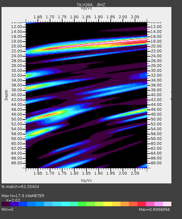
| Estimated Moho Depth: |
17.5 km |
| Estimated Crust Vp/Vs: |
2.02 |
| Assumed Crust Vp: |
6.571 km/s |
| Estimated Crust Vs: |
3.253 km/s |
| Estimated Crust Poisson's Ratio: |
0.34 |
|
| Radial Match: |
93.20404 % |
| Radial Bump: |
400 |
| Transverse Match: |
78.784096 % |
| Transverse Bump: |
400 |
| SOD ConfigId: |
424168 |
| Insert Time: |
2012-02-16 11:12:32.882 +0000 |
| GWidth: |
2.5 |
| Max Bumps: |
400 |
| Tol: |
0.001 |
|
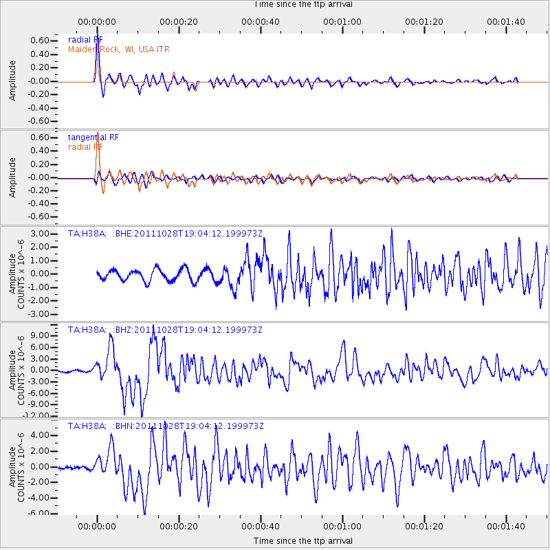
Signal To Noise
| Channel | StoN | STA | LTA |
| TA:H38A: :BHZ:20111028T19:04:12.199973Z | 20.015055 | 4.3087143E-6 | 2.1527366E-7 |
| TA:H38A: :BHN:20111028T19:04:12.199973Z | 4.5905595 | 1.8476379E-6 | 4.0248645E-7 |
| TA:H38A: :BHE:20111028T19:04:12.199973Z | 1.8320143 | 7.6538413E-7 | 4.1778281E-7 |
| Arrivals |
| Ps | 2.8 SECOND |
| PpPs | 7.7 SECOND |
| PsPs/PpSs | 11 SECOND |


