You are here: Home > Network List > TA - USArray Transportable Network (new EarthScope stations) Stations List
> Station G38A Ridgeland, WI, USA > Earthquake Result Viewer
G38A Ridgeland, WI, USA - Earthquake Result Viewer

| Earthquake location: |
Near Coast Of Peru |
| Earthquake latitude/longitude: |
-14.4/-76.0 |
| Earthquake time(UTC): |
2011/10/28 (301) 18:54:34 GMT |
| Earthquake Depth: |
24 km |
| Earthquake Magnitude: |
6.5 MB, 6.9 MS, 6.9 MW, 6.9 MW |
| Earthquake Catalog/Contributor: |
WHDF/NEIC |
|
| Network: |
TA USArray Transportable Network (new EarthScope stations) |
| Station: |
G38A Ridgeland, WI, USA |
| Lat/Lon: |
45.17 N/91.85 W |
| Elevation: |
370 m |
|
| Distance: |
61.1 deg |
| Az: |
347.214 deg |
| Baz: |
162.356 deg |
| Ray Param: |
0.06109388 |
| Estimated Moho Depth: |
11.0 km |
| Estimated Crust Vp/Vs: |
2.10 |
| Assumed Crust Vp: |
6.571 km/s |
| Estimated Crust Vs: |
3.133 km/s |
| Estimated Crust Poisson's Ratio: |
0.35 |
|
| Radial Match: |
93.84532 % |
| Radial Bump: |
328 |
| Transverse Match: |
69.453384 % |
| Transverse Bump: |
400 |
| SOD ConfigId: |
424168 |
| Insert Time: |
2012-02-16 11:12:39.856 +0000 |
| GWidth: |
2.5 |
| Max Bumps: |
400 |
| Tol: |
0.001 |
|
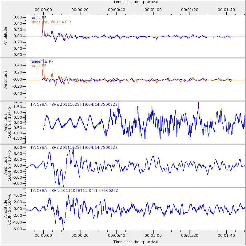
Signal To Noise
| Channel | StoN | STA | LTA |
| TA:G38A: :BHZ:20111028T19:04:14.750022Z | 9.429678 | 3.2453202E-6 | 3.4416024E-7 |
| TA:G38A: :BHN:20111028T19:04:14.750022Z | 5.5866466 | 1.5415959E-6 | 2.75943E-7 |
| TA:G38A: :BHE:20111028T19:04:14.750022Z | 1.456648 | 5.2164177E-7 | 3.5811107E-7 |
| Arrivals |
| Ps | 1.9 SECOND |
| PpPs | 5.0 SECOND |
| PsPs/PpSs | 6.9 SECOND |


