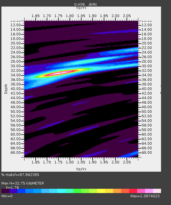
HYB Hyderabad, India - Earthquake Result Viewer

Earthquake location: Irian Jaya Region, Indonesia
Earthquake latitude/longitude: -3.7/135.3
Earthquake time(UTC): 2004/02/08 (039) 08:58:51 GMT
Earthquake Depth: 26 km
Earthquake Magnitude: 5.7 MB, 6.9 MS, 6.7 MW, 6.5 MW
Earthquake Catalog/Contributor: WHDF/NEIC
Network: G GEOSCOPE
Station: HYB Hyderabad, India
Lat/Lon: 17.42 N/78.55 E
Elevation: 510 m
Distance: 59.8 deg
Az: 292.454 deg
Baz: 104.97 deg
Ray Param: 0.061913162
Estimated Moho Depth: 32.75 km
Estimated Crust Vp/Vs: 1.76
Assumed Crust Vp: 6.459 km/s
Estimated Crust Vs: 3.67 km/s
Estimated Crust Poisson's Ratio: 0.26
Radial Match: 97.962395 %
Radial Bump: 242
Transverse Match: 76.989296 %
Transverse Bump: 400
SOD ConfigId: 2459
Insert Time: 2010-02-26 22:44:20.390 +0000
GWidth: 2.5
Max Bumps: 400
Tol: 0.001

Signal To Noise

ChannelStoNSTALTA
G:HYB: :BHN:20040208T09:08:23.800Z2.719041.5852619E-75.830227E-8
G:HYB: :BHE:20040208T09:08:23.800Z10.6133194.322378E-74.0725975E-8
G:HYB: :BHZ:20040208T09:08:23.800Z13.7730151.069976E-67.76864E-8
Arrivals
Ps4.0 SECOND
PpPs13 SECOND
PsPs/PpSs17 SECOND