You are here: Home > Network List > TA - USArray Transportable Network (new EarthScope stations) Stations List
> Station E42A Champion, MI, USA > Earthquake Result Viewer
E42A Champion, MI, USA - Earthquake Result Viewer
| Earthquake location: |
Near Coast Of Peru |
| Earthquake latitude/longitude: |
-14.4/-76.0 |
| Earthquake time(UTC): |
2011/10/28 (301) 18:54:34 GMT |
| Earthquake Depth: |
24 km |
| Earthquake Magnitude: |
6.5 MB, 6.9 MS, 6.9 MW, 6.9 MW |
| Earthquake Catalog/Contributor: |
WHDF/NEIC |
|
| Network: |
TA USArray Transportable Network (new EarthScope stations) |
| Station: |
E42A Champion, MI, USA |
| Lat/Lon: |
46.43 N/87.91 W |
| Elevation: |
475 m |
|
| Distance: |
61.5 deg |
| Az: |
350.626 deg |
| Baz: |
166.812 deg |
| Ray Param: |
0.06078101 |
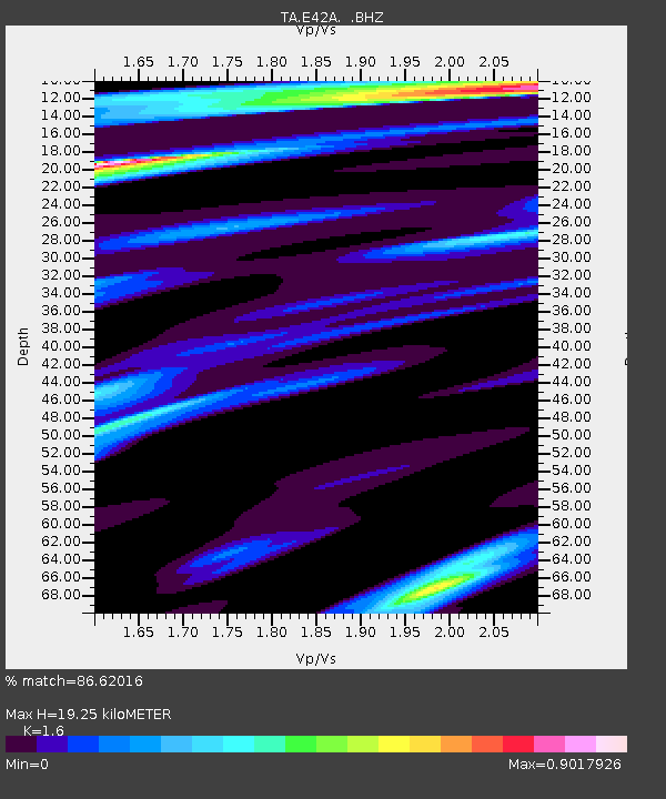
| Estimated Moho Depth: |
19.25 km |
| Estimated Crust Vp/Vs: |
1.60 |
| Assumed Crust Vp: |
6.472 km/s |
| Estimated Crust Vs: |
4.045 km/s |
| Estimated Crust Poisson's Ratio: |
0.18 |
|
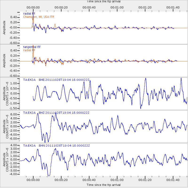
| Radial Match: |
86.62016 % |
| Radial Bump: |
325 |
| Transverse Match: |
77.75697 % |
| Transverse Bump: |
399 |
| SOD ConfigId: |
424168 |
| Insert Time: |
2012-02-16 11:14:33.942 +0000 |
| GWidth: |
2.5 |
| Max Bumps: |
400 |
| Tol: |
0.001 |
|
Signal To Noise
| Channel | StoN | STA | LTA |
| TA:E42A: :BHZ:20111028T19:04:18.000022Z | 8.075805 | 3.1127627E-6 | 3.8544303E-7 |
| TA:E42A: :BHN:20111028T19:04:18.000022Z | 7.884014 | 1.4711954E-6 | 1.8660486E-7 |
| TA:E42A: :BHE:20111028T19:04:18.000022Z | 0.76384383 | 3.5845875E-7 | 4.6928278E-7 |
| Arrivals |
| Ps | 1.9 SECOND |
| PpPs | 7.3 SECOND |
| PsPs/PpSs | 9.2 SECOND |


