You are here: Home > Network List > TA - USArray Transportable Network (new EarthScope stations) Stations List
> Station G43A Wallace, MI, USA > Earthquake Result Viewer
G43A Wallace, MI, USA - Earthquake Result Viewer
| Earthquake location: |
Near Coast Of Peru |
| Earthquake latitude/longitude: |
-14.4/-76.0 |
| Earthquake time(UTC): |
2011/10/28 (301) 18:54:34 GMT |
| Earthquake Depth: |
24 km |
| Earthquake Magnitude: |
6.5 MB, 6.9 MS, 6.9 MW, 6.9 MW |
| Earthquake Catalog/Contributor: |
WHDF/NEIC |
|
| Network: |
TA USArray Transportable Network (new EarthScope stations) |
| Station: |
G43A Wallace, MI, USA |
| Lat/Lon: |
45.26 N/87.69 W |
| Elevation: |
213 m |
|
| Distance: |
60.4 deg |
| Az: |
350.498 deg |
| Baz: |
166.913 deg |
| Ray Param: |
0.061553974 |
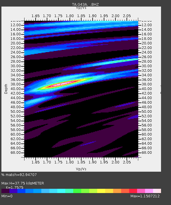
| Estimated Moho Depth: |
37.75 km |
| Estimated Crust Vp/Vs: |
1.76 |
| Assumed Crust Vp: |
6.53 km/s |
| Estimated Crust Vs: |
3.716 km/s |
| Estimated Crust Poisson's Ratio: |
0.26 |
|
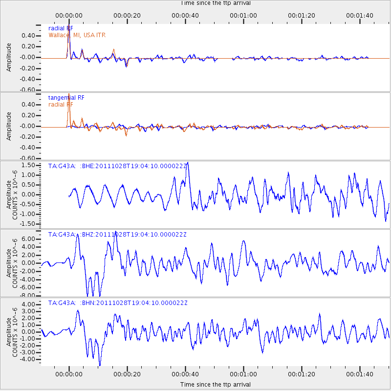
| Radial Match: |
92.94707 % |
| Radial Bump: |
322 |
| Transverse Match: |
66.20843 % |
| Transverse Bump: |
400 |
| SOD ConfigId: |
424168 |
| Insert Time: |
2012-02-16 11:14:45.396 +0000 |
| GWidth: |
2.5 |
| Max Bumps: |
400 |
| Tol: |
0.001 |
|
Signal To Noise
| Channel | StoN | STA | LTA |
| TA:G43A: :BHZ:20111028T19:04:10.000022Z | 8.652342 | 3.2410103E-6 | 3.7458184E-7 |
| TA:G43A: :BHN:20111028T19:04:10.000022Z | 6.6953793 | 1.5408979E-6 | 2.3014348E-7 |
| TA:G43A: :BHE:20111028T19:04:10.000022Z | 1.2067571 | 3.8784967E-7 | 3.213983E-7 |
| Arrivals |
| Ps | 4.6 SECOND |
| PpPs | 15 SECOND |
| PsPs/PpSs | 20 SECOND |


