You are here: Home > Network List > UW - Pacific Northwest Regional Seismic Network Stations List
> Station OMAK Colville Reservation, Omak, WA, USA > Earthquake Result Viewer
OMAK Colville Reservation, Omak, WA, USA - Earthquake Result Viewer
| Earthquake location: |
Near Coast Of Peru |
| Earthquake latitude/longitude: |
-14.4/-76.0 |
| Earthquake time(UTC): |
2011/10/28 (301) 18:54:34 GMT |
| Earthquake Depth: |
24 km |
| Earthquake Magnitude: |
6.5 MB, 6.9 MS, 6.9 MW, 6.9 MW |
| Earthquake Catalog/Contributor: |
WHDF/NEIC |
|
| Network: |
UW Pacific Northwest Regional Seismic Network |
| Station: |
OMAK Colville Reservation, Omak, WA, USA |
| Lat/Lon: |
48.36 N/119.33 W |
| Elevation: |
696 m |
|
| Distance: |
73.4 deg |
| Az: |
331.457 deg |
| Baz: |
136.047 deg |
| Ray Param: |
0.05297882 |
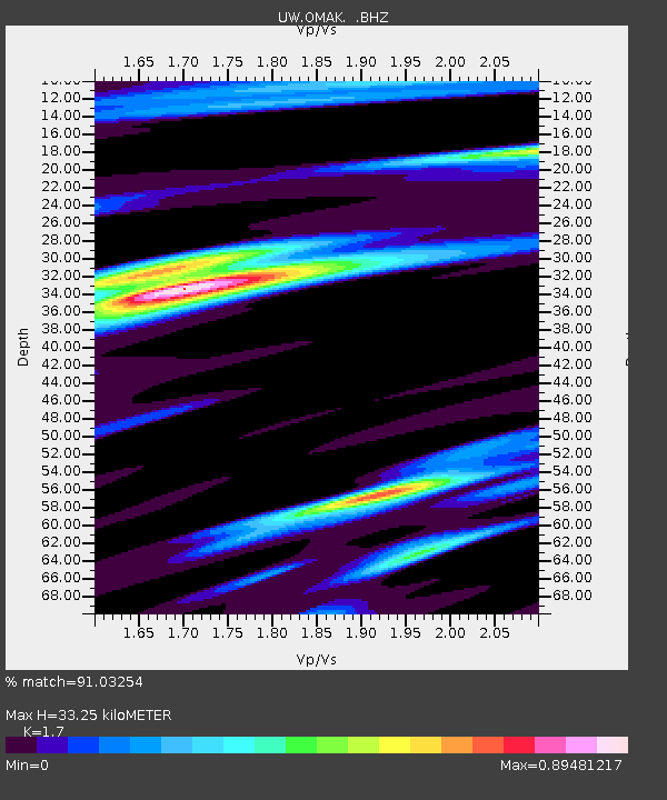
| Estimated Moho Depth: |
33.25 km |
| Estimated Crust Vp/Vs: |
1.70 |
| Assumed Crust Vp: |
6.419 km/s |
| Estimated Crust Vs: |
3.776 km/s |
| Estimated Crust Poisson's Ratio: |
0.24 |
|
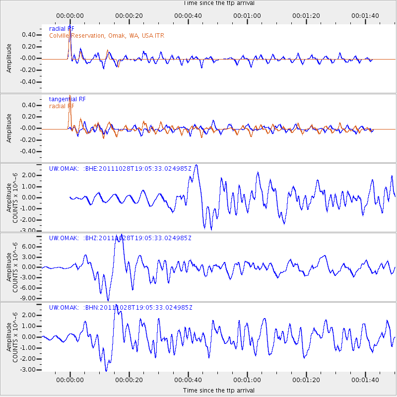
| Radial Match: |
91.03254 % |
| Radial Bump: |
400 |
| Transverse Match: |
78.70475 % |
| Transverse Bump: |
400 |
| SOD ConfigId: |
424168 |
| Insert Time: |
2012-02-16 11:18:08.868 +0000 |
| GWidth: |
2.5 |
| Max Bumps: |
400 |
| Tol: |
0.001 |
|
Signal To Noise
| Channel | StoN | STA | LTA |
| UW:OMAK: :BHZ:20111028T19:05:33.024985Z | 3.9819477 | 1.0110326E-6 | 2.5390406E-7 |
| UW:OMAK: :BHN:20111028T19:05:33.024985Z | 2.2410293 | 4.6808046E-7 | 2.0886853E-7 |
| UW:OMAK: :BHE:20111028T19:05:33.024985Z | 2.0337608 | 5.676652E-7 | 2.7912094E-7 |
| Arrivals |
| Ps | 3.8 SECOND |
| PpPs | 13 SECOND |
| PsPs/PpSs | 17 SECOND |


