You are here: Home > Network List > UW - Pacific Northwest Regional Seismic Network Stations List
> Station KENT Carlson Farm, Grass Valley, OR, USA > Earthquake Result Viewer
KENT Carlson Farm, Grass Valley, OR, USA - Earthquake Result Viewer
| Earthquake location: |
Near Coast Of Peru |
| Earthquake latitude/longitude: |
-14.4/-76.0 |
| Earthquake time(UTC): |
2011/10/28 (301) 18:54:34 GMT |
| Earthquake Depth: |
24 km |
| Earthquake Magnitude: |
6.5 MB, 6.9 MS, 6.9 MW, 6.9 MW |
| Earthquake Catalog/Contributor: |
WHDF/NEIC |
|
| Network: |
UW Pacific Northwest Regional Seismic Network |
| Station: |
KENT Carlson Farm, Grass Valley, OR, USA |
| Lat/Lon: |
45.24 N/120.64 W |
| Elevation: |
780 m |
|
| Distance: |
71.9 deg |
| Az: |
328.484 deg |
| Baz: |
134.213 deg |
| Ray Param: |
0.05402374 |
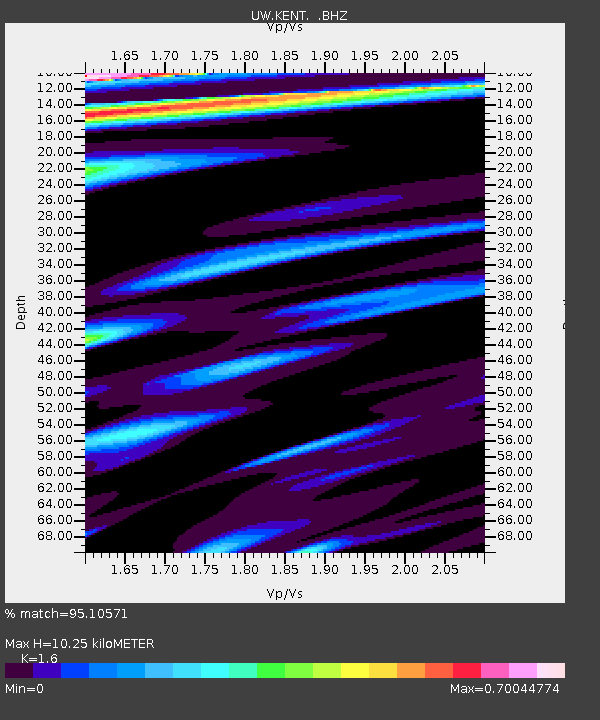
| Estimated Moho Depth: |
10.25 km |
| Estimated Crust Vp/Vs: |
1.60 |
| Assumed Crust Vp: |
6.597 km/s |
| Estimated Crust Vs: |
4.123 km/s |
| Estimated Crust Poisson's Ratio: |
0.18 |
|
| Radial Match: |
95.10571 % |
| Radial Bump: |
252 |
| Transverse Match: |
95.13769 % |
| Transverse Bump: |
246 |
| SOD ConfigId: |
424168 |
| Insert Time: |
2012-02-16 11:18:20.560 +0000 |
| GWidth: |
2.5 |
| Max Bumps: |
400 |
| Tol: |
0.001 |
|
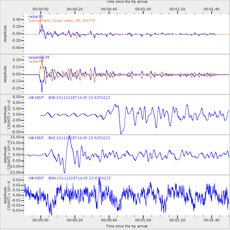
Signal To Noise
| Channel | StoN | STA | LTA |
| UW:KENT: :BHZ:20111028T19:05:23.625022Z | 2.691761 | 7.913597E-7 | 2.939933E-7 |
| UW:KENT: :BHN:20111028T19:05:23.625022Z | 1.2557439 | 1.170902E-8 | 9.32437E-9 |
| UW:KENT: :BHE:20111028T19:05:23.625022Z | 0.9854332 | 3.6488527E-7 | 3.7027903E-7 |
| Arrivals |
| Ps | 1.0 SECOND |
| PpPs | 3.9 SECOND |
| PsPs/PpSs | 4.8 SECOND |


