You are here: Home > Network List > TA - USArray Transportable Network (new EarthScope stations) Stations List
> Station M04C Macdoel, CA, USA > Earthquake Result Viewer
M04C Macdoel, CA, USA - Earthquake Result Viewer
*The percent match for this event was below the threshold and hence no stack was calculated.
| Earthquake location: |
Near Coast Of Peru |
| Earthquake latitude/longitude: |
-14.4/-76.0 |
| Earthquake time(UTC): |
2011/10/28 (301) 19:01:02 GMT |
| Earthquake Depth: |
22 km |
| Earthquake Magnitude: |
5.6 MB |
| Earthquake Catalog/Contributor: |
WHDF/NEIC |
|
| Network: |
TA USArray Transportable Network (new EarthScope stations) |
| Station: |
M04C Macdoel, CA, USA |
| Lat/Lon: |
41.78 N/121.84 W |
| Elevation: |
1391 m |
|
| Distance: |
70.1 deg |
| Az: |
325.195 deg |
| Baz: |
132.304 deg |
| Ray Param: |
$rayparam |
*The percent match for this event was below the threshold and hence was not used in the summary stack. |
|
| Radial Match: |
74.555984 % |
| Radial Bump: |
400 |
| Transverse Match: |
74.624275 % |
| Transverse Bump: |
400 |
| SOD ConfigId: |
424168 |
| Insert Time: |
2012-02-16 11:25:05.374 +0000 |
| GWidth: |
2.5 |
| Max Bumps: |
400 |
| Tol: |
0.001 |
|
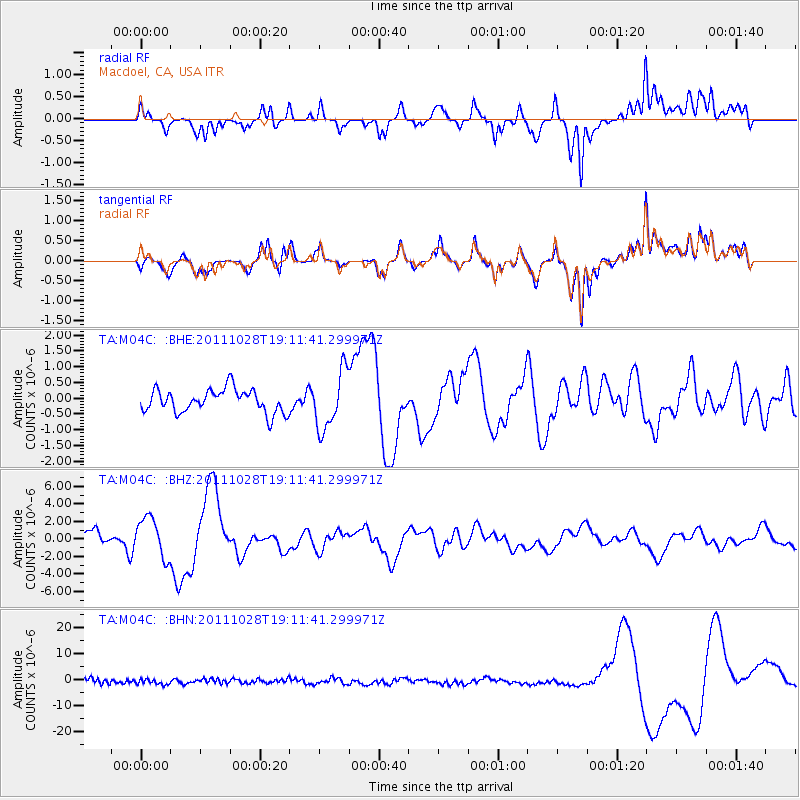
Signal To Noise
| Channel | StoN | STA | LTA |
| TA:M04C: :BHZ:20111028T19:11:41.299971Z | 3.7762618 | 2.2677846E-6 | 6.005369E-7 |
| TA:M04C: :BHN:20111028T19:11:41.299971Z | 0.7865462 | 9.720218E-7 | 1.2358101E-6 |
| TA:M04C: :BHE:20111028T19:11:41.299971Z | 2.490894 | 9.146226E-7 | 3.671865E-7 |
| Arrivals |
| Ps | |
| PpPs | |
| PsPs/PpSs | |


