You are here: Home > Network List > II - Global Seismograph Network (GSN - IRIS/IDA) Stations List
> Station TAU Hobart, Tasmania, Australia > Earthquake Result Viewer
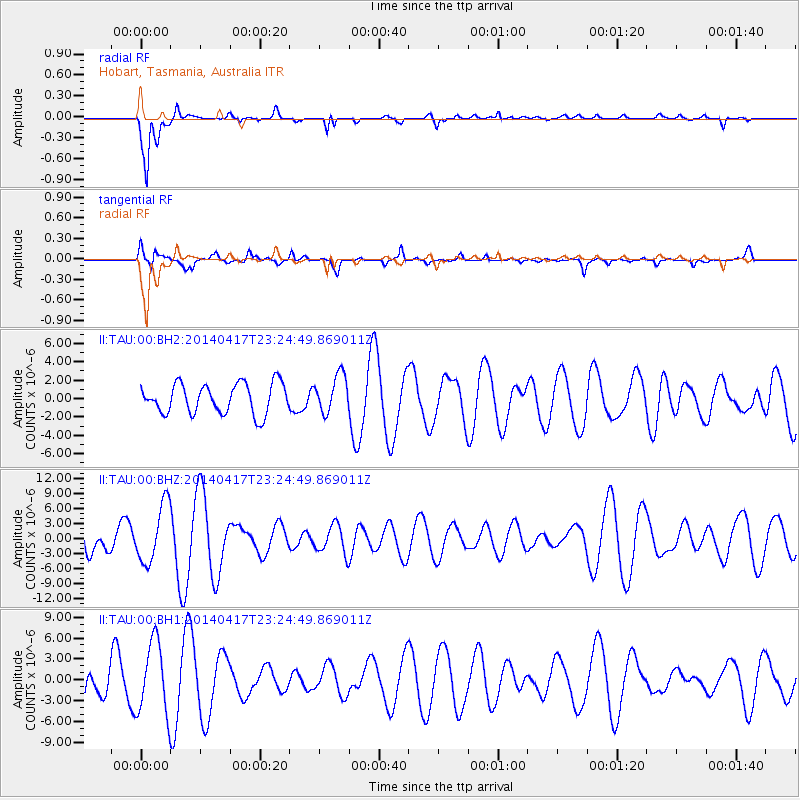
TAU Hobart, Tasmania, Australia - Earthquake Result Viewer
*The percent match for this event was below the threshold and hence no stack was calculated.
| Earthquake location: |
South Sandwich Islands Region |
| Earthquake latitude/longitude: |
-55.5/-28.2 |
| Earthquake time(UTC): |
2014/04/17 (107) 23:13:04 GMT |
| Earthquake Depth: |
26 km |
| Earthquake Magnitude: |
5.2 MW |
| Earthquake Catalog/Contributor: |
ISC/ISC |
|
| Network: |
II Global Seismograph Network (GSN - IRIS/IDA) |
| Station: |
TAU Hobart, Tasmania, Australia |
| Lat/Lon: |
42.91 S/147.32 E |
| Elevation: |
132 m |
|
| Distance: |
81.9 deg |
| Az: |
176.678 deg |
| Baz: |
182.57 deg |
| Ray Param: |
$rayparam |
*The percent match for this event was below the threshold and hence was not used in the summary stack. |
|
| Radial Match: |
92.44431 % |
| Radial Bump: |
331 |
| Transverse Match: |
74.88218 % |
| Transverse Bump: |
400 |
| SOD ConfigId: |
3390531 |
| Insert Time: |
2019-04-11 10:48:35.375 +0000 |
| GWidth: |
2.5 |
| Max Bumps: |
400 |
| Tol: |
0.001 |
|
Signal To Noise
| Channel | StoN | STA | LTA |
| II:TAU:00:BHZ:20140417T23:24:49.869011Z | 1.596356 | 5.807243E-6 | 3.637812E-6 |
| II:TAU:00:BH1:20140417T23:24:49.869011Z | 2.0519207 | 5.1648954E-6 | 2.517103E-6 |
| II:TAU:00:BH2:20140417T23:24:49.869011Z | 1.2587866 | 2.0399577E-6 | 1.6205747E-6 |
| Arrivals |
| Ps | |
| PpPs | |
| PsPs/PpSs | |


