You are here: Home > Network List > G - GEOSCOPE Stations List
> Station HYB Hyderabad, India > Earthquake Result Viewer
HYB Hyderabad, India - Earthquake Result Viewer
| Earthquake location: |
Banda Sea |
| Earthquake latitude/longitude: |
-4.5/129.1 |
| Earthquake time(UTC): |
1998/02/19 (050) 14:14:51 GMT |
| Earthquake Depth: |
33 km |
| Earthquake Magnitude: |
6.1 MB, 6.4 MS, 6.5 UNKNOWN, 6.5 MW |
| Earthquake Catalog/Contributor: |
WHDF/NEIC |
|
| Network: |
G GEOSCOPE |
| Station: |
HYB Hyderabad, India |
| Lat/Lon: |
17.42 N/78.55 E |
| Elevation: |
510 m |
|
| Distance: |
54.4 deg |
| Az: |
294.999 deg |
| Baz: |
108.837 deg |
| Ray Param: |
0.065409236 |
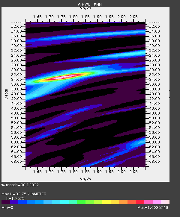
| Estimated Moho Depth: |
32.75 km |
| Estimated Crust Vp/Vs: |
1.76 |
| Assumed Crust Vp: |
6.459 km/s |
| Estimated Crust Vs: |
3.675 km/s |
| Estimated Crust Poisson's Ratio: |
0.26 |
|
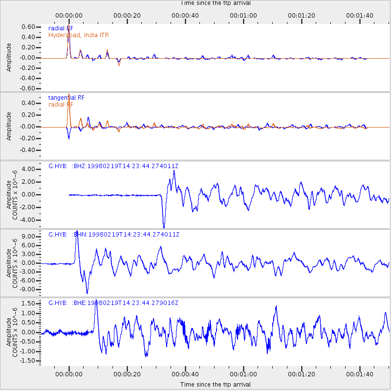
| Radial Match: |
98.13022 % |
| Radial Bump: |
238 |
| Transverse Match: |
92.29844 % |
| Transverse Bump: |
400 |
| SOD ConfigId: |
4480 |
| Insert Time: |
2010-02-26 22:44:39.974 +0000 |
| GWidth: |
2.5 |
| Max Bumps: |
400 |
| Tol: |
0.001 |
|
Signal To Noise
| Channel | StoN | STA | LTA |
| G:HYB: :BHN:19980219T14:23:44.274011Z | 51.159298 | 4.5294228E-6 | 8.853567E-8 |
| G:HYB: :BHE:19980219T14:23:44.279016Z | 0.7843076 | 4.8061732E-8 | 6.127919E-8 |
| G:HYB: :BHZ:19980219T14:23:44.274011Z | 48.653507 | 2.0671912E-6 | 4.248802E-8 |
| Arrivals |
| Ps | 4.1 SECOND |
| PpPs | 13 SECOND |
| PsPs/PpSs | 17 SECOND |


