You are here: Home > Network List > UW - Pacific Northwest Regional Seismic Network Stations List
> Station GNW Green Mountain (BB) > Earthquake Result Viewer
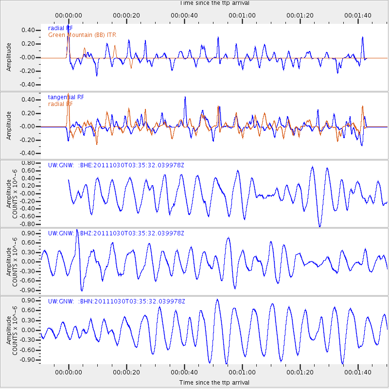
GNW Green Mountain (BB) - Earthquake Result Viewer
*The percent match for this event was below the threshold and hence no stack was calculated.
| Earthquake location: |
Taiwan Region |
| Earthquake latitude/longitude: |
25.4/122.9 |
| Earthquake time(UTC): |
2011/10/30 (303) 03:23:46 GMT |
| Earthquake Depth: |
224 km |
| Earthquake Magnitude: |
5.7 MW, 5.4 MB, 5.7 MW |
| Earthquake Catalog/Contributor: |
WHDF/NEIC |
|
| Network: |
UW Pacific Northwest Regional Seismic Network |
| Station: |
GNW Green Mountain (BB) |
| Lat/Lon: |
47.56 N/122.83 W |
| Elevation: |
160 m |
|
| Distance: |
86.5 deg |
| Az: |
38.196 deg |
| Baz: |
304.31 deg |
| Ray Param: |
$rayparam |
*The percent match for this event was below the threshold and hence was not used in the summary stack. |
|
| Radial Match: |
66.109024 % |
| Radial Bump: |
355 |
| Transverse Match: |
72.93606 % |
| Transverse Bump: |
369 |
| SOD ConfigId: |
424168 |
| Insert Time: |
2012-02-17 12:47:38.811 +0000 |
| GWidth: |
2.5 |
| Max Bumps: |
400 |
| Tol: |
0.001 |
|
Signal To Noise
| Channel | StoN | STA | LTA |
| UW:GNW: :BHZ:20111030T03:35:32.039978Z | 1.9837805 | 5.329994E-7 | 2.6867863E-7 |
| UW:GNW: :BHN:20111030T03:35:32.039978Z | 0.4428422 | 1.4664717E-7 | 3.3114995E-7 |
| UW:GNW: :BHE:20111030T03:35:32.039978Z | 1.2128602 | 3.2474406E-7 | 2.677506E-7 |
| Arrivals |
| Ps | |
| PpPs | |
| PsPs/PpSs | |


