You are here: Home > Network List > UW - Pacific Northwest Regional Seismic Network Stations List
> Station MRBL Marblemount, WA, USA > Earthquake Result Viewer
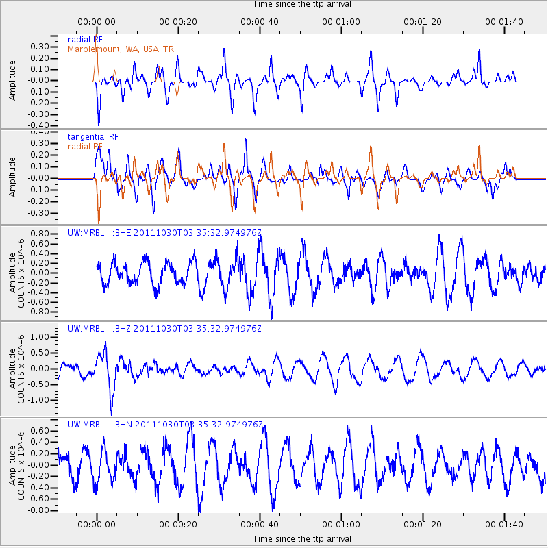
MRBL Marblemount, WA, USA - Earthquake Result Viewer
*The percent match for this event was below the threshold and hence no stack was calculated.
| Earthquake location: |
Taiwan Region |
| Earthquake latitude/longitude: |
25.4/122.9 |
| Earthquake time(UTC): |
2011/10/30 (303) 03:23:46 GMT |
| Earthquake Depth: |
224 km |
| Earthquake Magnitude: |
5.7 MW, 5.4 MB, 5.7 MW |
| Earthquake Catalog/Contributor: |
WHDF/NEIC |
|
| Network: |
UW Pacific Northwest Regional Seismic Network |
| Station: |
MRBL Marblemount, WA, USA |
| Lat/Lon: |
48.52 N/121.48 W |
| Elevation: |
75 m |
|
| Distance: |
86.7 deg |
| Az: |
36.896 deg |
| Baz: |
305.226 deg |
| Ray Param: |
$rayparam |
*The percent match for this event was below the threshold and hence was not used in the summary stack. |
|
| Radial Match: |
53.29184 % |
| Radial Bump: |
280 |
| Transverse Match: |
59.110935 % |
| Transverse Bump: |
400 |
| SOD ConfigId: |
424168 |
| Insert Time: |
2012-02-17 12:48:06.872 +0000 |
| GWidth: |
2.5 |
| Max Bumps: |
400 |
| Tol: |
0.001 |
|
Signal To Noise
| Channel | StoN | STA | LTA |
| UW:MRBL: :BHZ:20111030T03:35:32.974976Z | 2.2804694 | 5.9934433E-7 | 2.628162E-7 |
| UW:MRBL: :BHN:20111030T03:35:32.974976Z | 0.91669136 | 2.6785173E-7 | 2.9219402E-7 |
| UW:MRBL: :BHE:20111030T03:35:32.974976Z | 1.3999647 | 2.981676E-7 | 2.1298223E-7 |
| Arrivals |
| Ps | |
| PpPs | |
| PsPs/PpSs | |


