You are here: Home > Network List > G - GEOSCOPE Stations List
> Station HYB Hyderabad, India > Earthquake Result Viewer
HYB Hyderabad, India - Earthquake Result Viewer
| Earthquake location: |
Irian Jaya Region, Indonesia |
| Earthquake latitude/longitude: |
-3.0/136.3 |
| Earthquake time(UTC): |
1998/04/27 (117) 18:40:38 GMT |
| Earthquake Depth: |
53 km |
| Earthquake Magnitude: |
5.5 MB, 6.2 UNKNOWN, 6.0 MW |
| Earthquake Catalog/Contributor: |
WHDF/NEIC |
|
| Network: |
G GEOSCOPE |
| Station: |
HYB Hyderabad, India |
| Lat/Lon: |
17.42 N/78.55 E |
| Elevation: |
510 m |
|
| Distance: |
60.4 deg |
| Az: |
291.841 deg |
| Baz: |
103.85 deg |
| Ray Param: |
0.061419897 |
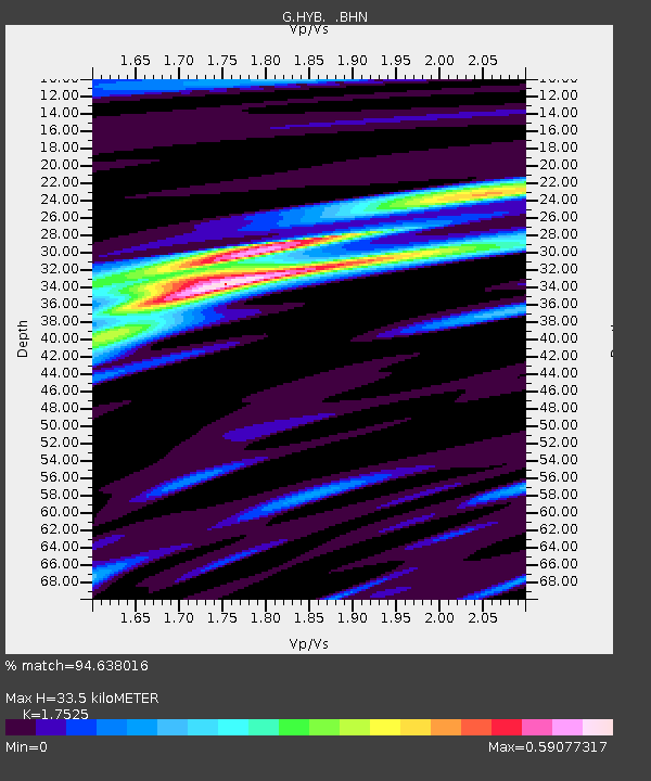
| Estimated Moho Depth: |
33.5 km |
| Estimated Crust Vp/Vs: |
1.75 |
| Assumed Crust Vp: |
6.459 km/s |
| Estimated Crust Vs: |
3.686 km/s |
| Estimated Crust Poisson's Ratio: |
0.26 |
|
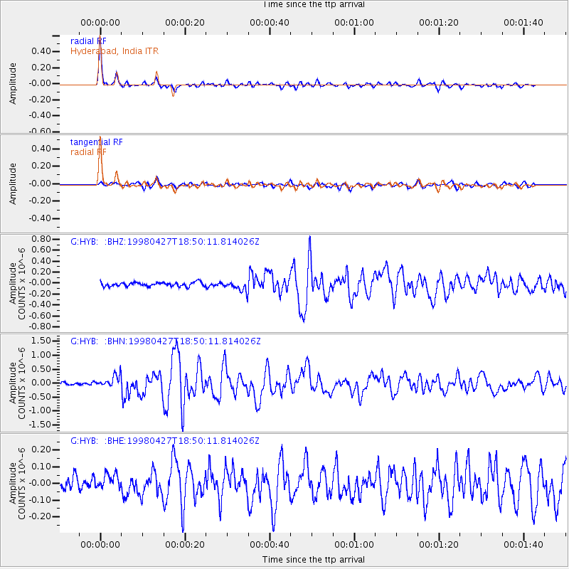
| Radial Match: |
94.638016 % |
| Radial Bump: |
336 |
| Transverse Match: |
79.36298 % |
| Transverse Bump: |
400 |
| SOD ConfigId: |
4480 |
| Insert Time: |
2010-02-26 22:44:52.523 +0000 |
| GWidth: |
2.5 |
| Max Bumps: |
400 |
| Tol: |
0.001 |
|
Signal To Noise
| Channel | StoN | STA | LTA |
| G:HYB: :BHN:19980427T18:50:11.814026Z | 3.8322139 | 2.202703E-7 | 5.74786E-8 |
| G:HYB: :BHE:19980427T18:50:11.814026Z | 1.1602194 | 5.817375E-8 | 5.0140297E-8 |
| G:HYB: :BHZ:19980427T18:50:11.814026Z | 2.651578 | 9.5085205E-8 | 3.5859856E-8 |
| Arrivals |
| Ps | 4.1 SECOND |
| PpPs | 14 SECOND |
| PsPs/PpSs | 18 SECOND |


