You are here: Home > Network List > CI - Caltech Regional Seismic Network Stations List
> Station FUR Furnace Creek, CA, USA > Earthquake Result Viewer
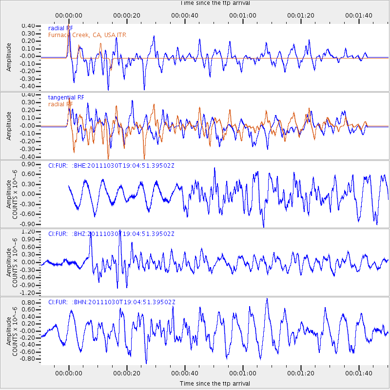
FUR Furnace Creek, CA, USA - Earthquake Result Viewer
*The percent match for this event was below the threshold and hence no stack was calculated.
| Earthquake location: |
Near Coast Of Northern Chile |
| Earthquake latitude/longitude: |
-25.7/-71.0 |
| Earthquake time(UTC): |
2011/10/30 (303) 18:53:43 GMT |
| Earthquake Depth: |
47 km |
| Earthquake Magnitude: |
5.7 MB, 5.4 MS, 5.7 MW, 5.8 MW |
| Earthquake Catalog/Contributor: |
WHDF/NEIC |
|
| Network: |
CI Caltech Regional Seismic Network |
| Station: |
FUR Furnace Creek, CA, USA |
| Lat/Lon: |
36.47 N/116.86 W |
| Elevation: |
-37.0 m |
|
| Distance: |
75.5 deg |
| Az: |
323.276 deg |
| Baz: |
138.008 deg |
| Ray Param: |
$rayparam |
*The percent match for this event was below the threshold and hence was not used in the summary stack. |
|
| Radial Match: |
66.48132 % |
| Radial Bump: |
400 |
| Transverse Match: |
54.964565 % |
| Transverse Bump: |
400 |
| SOD ConfigId: |
424168 |
| Insert Time: |
2012-02-17 12:57:59.099 +0000 |
| GWidth: |
2.5 |
| Max Bumps: |
400 |
| Tol: |
0.001 |
|
Signal To Noise
| Channel | StoN | STA | LTA |
| CI:FUR: :BHZ:20111030T19:04:51.39502Z | 0.8549606 | 9.725371E-8 | 1.1375227E-7 |
| CI:FUR: :BHN:20111030T19:04:51.39502Z | 2.4843755 | 3.9710062E-7 | 1.5983922E-7 |
| CI:FUR: :BHE:20111030T19:04:51.39502Z | 0.8341605 | 2.1142095E-7 | 2.5345358E-7 |
| Arrivals |
| Ps | |
| PpPs | |
| PsPs/PpSs | |


