You are here: Home > Network List > TA - USArray Transportable Network (new EarthScope stations) Stations List
> Station O41A Passley's Farm, La Prairie, IL, USA > Earthquake Result Viewer
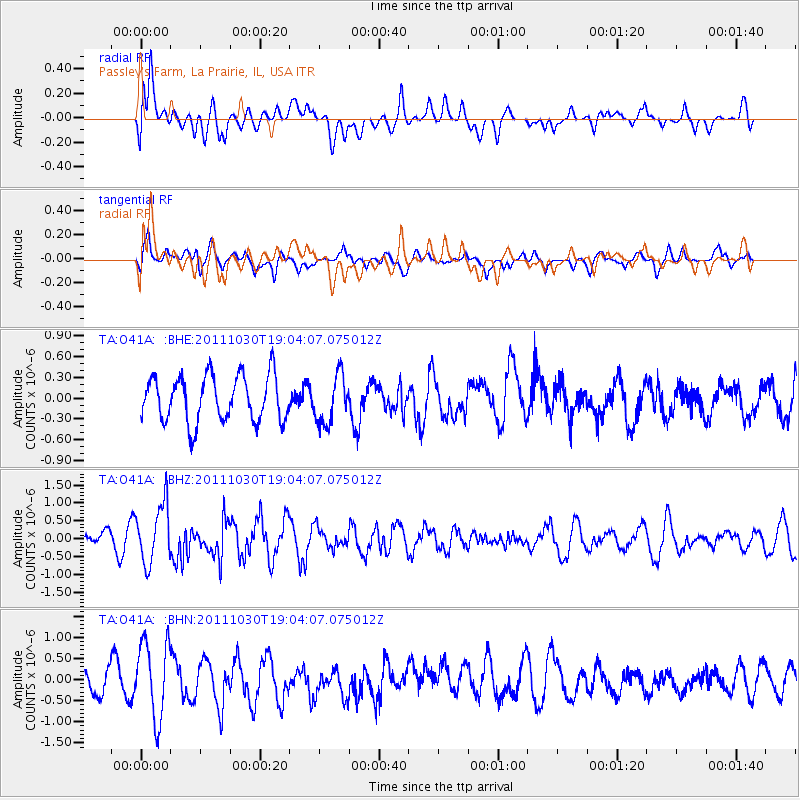
O41A Passley's Farm, La Prairie, IL, USA - Earthquake Result Viewer
*The percent match for this event was below the threshold and hence no stack was calculated.
| Earthquake location: |
Near Coast Of Northern Chile |
| Earthquake latitude/longitude: |
-25.7/-71.0 |
| Earthquake time(UTC): |
2011/10/30 (303) 18:53:43 GMT |
| Earthquake Depth: |
47 km |
| Earthquake Magnitude: |
5.7 MB, 5.4 MS, 5.7 MW, 5.8 MW |
| Earthquake Catalog/Contributor: |
WHDF/NEIC |
|
| Network: |
TA USArray Transportable Network (new EarthScope stations) |
| Station: |
O41A Passley's Farm, La Prairie, IL, USA |
| Lat/Lon: |
40.12 N/90.88 W |
| Elevation: |
203 m |
|
| Distance: |
68.1 deg |
| Az: |
343.641 deg |
| Baz: |
160.656 deg |
| Ray Param: |
$rayparam |
*The percent match for this event was below the threshold and hence was not used in the summary stack. |
|
| Radial Match: |
47.47754 % |
| Radial Bump: |
400 |
| Transverse Match: |
66.527664 % |
| Transverse Bump: |
400 |
| SOD ConfigId: |
424168 |
| Insert Time: |
2012-02-17 13:07:21.159 +0000 |
| GWidth: |
2.5 |
| Max Bumps: |
400 |
| Tol: |
0.001 |
|
Signal To Noise
| Channel | StoN | STA | LTA |
| TA:O41A: :BHZ:20111030T19:04:07.075012Z | 3.2316039 | 8.2351096E-7 | 2.548304E-7 |
| TA:O41A: :BHN:20111030T19:04:07.075012Z | 2.9264557 | 9.1253236E-7 | 3.1182168E-7 |
| TA:O41A: :BHE:20111030T19:04:07.075012Z | 1.0363503 | 3.4377388E-7 | 3.317159E-7 |
| Arrivals |
| Ps | |
| PpPs | |
| PsPs/PpSs | |


