You are here: Home > Network List > CI - Caltech Regional Seismic Network Stations List
> Station SLA SLA, Trona, CA, USA > Earthquake Result Viewer
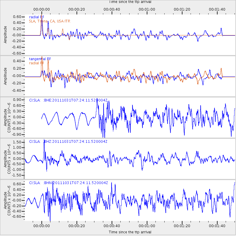
SLA SLA, Trona, CA, USA - Earthquake Result Viewer
*The percent match for this event was below the threshold and hence no stack was calculated.
| Earthquake location: |
Rat Islands, Aleutian Islands |
| Earthquake latitude/longitude: |
52.4/177.9 |
| Earthquake time(UTC): |
2011/10/31 (304) 07:16:21 GMT |
| Earthquake Depth: |
159 km |
| Earthquake Magnitude: |
5.8 MB, 5.8 MW, 5.9 MW |
| Earthquake Catalog/Contributor: |
WHDF/NEIC |
|
| Network: |
CI Caltech Regional Seismic Network |
| Station: |
SLA SLA, Trona, CA, USA |
| Lat/Lon: |
35.89 N/117.28 W |
| Elevation: |
1174 m |
|
| Distance: |
47.7 deg |
| Az: |
83.428 deg |
| Baz: |
311.393 deg |
| Ray Param: |
$rayparam |
*The percent match for this event was below the threshold and hence was not used in the summary stack. |
|
| Radial Match: |
59.165928 % |
| Radial Bump: |
400 |
| Transverse Match: |
72.61533 % |
| Transverse Bump: |
400 |
| SOD ConfigId: |
424168 |
| Insert Time: |
2012-02-17 13:20:07.407 +0000 |
| GWidth: |
2.5 |
| Max Bumps: |
400 |
| Tol: |
0.001 |
|
Signal To Noise
| Channel | StoN | STA | LTA |
| CI:SLA: :BHZ:20111031T07:24:11.520004Z | 3.1001291 | 5.211E-7 | 1.6808978E-7 |
| CI:SLA: :BHN:20111031T07:24:11.520004Z | 1.271954 | 2.8021918E-7 | 2.2030605E-7 |
| CI:SLA: :BHE:20111031T07:24:11.520004Z | 1.8889879 | 4.2877096E-7 | 2.2698448E-7 |
| Arrivals |
| Ps | |
| PpPs | |
| PsPs/PpSs | |


