You are here: Home > Network List > CI - Caltech Regional Seismic Network Stations List
> Station SMM Simmler, CA, USA > Earthquake Result Viewer
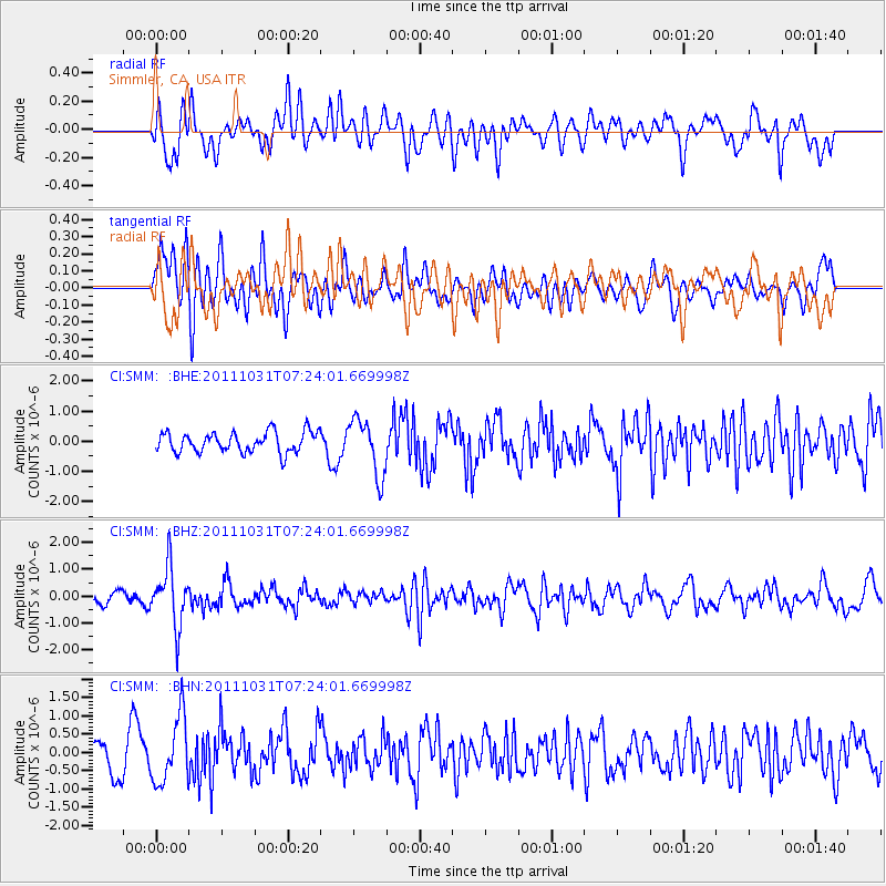
SMM Simmler, CA, USA - Earthquake Result Viewer
*The percent match for this event was below the threshold and hence no stack was calculated.
| Earthquake location: |
Rat Islands, Aleutian Islands |
| Earthquake latitude/longitude: |
52.4/177.9 |
| Earthquake time(UTC): |
2011/10/31 (304) 07:16:21 GMT |
| Earthquake Depth: |
159 km |
| Earthquake Magnitude: |
5.8 MB, 5.8 MW, 5.9 MW |
| Earthquake Catalog/Contributor: |
WHDF/NEIC |
|
| Network: |
CI Caltech Regional Seismic Network |
| Station: |
SMM Simmler, CA, USA |
| Lat/Lon: |
35.31 N/120.00 W |
| Elevation: |
599 m |
|
| Distance: |
46.4 deg |
| Az: |
86.018 deg |
| Baz: |
311.585 deg |
| Ray Param: |
$rayparam |
*The percent match for this event was below the threshold and hence was not used in the summary stack. |
|
| Radial Match: |
57.151947 % |
| Radial Bump: |
400 |
| Transverse Match: |
56.694572 % |
| Transverse Bump: |
400 |
| SOD ConfigId: |
424168 |
| Insert Time: |
2012-02-17 13:20:24.720 +0000 |
| GWidth: |
2.5 |
| Max Bumps: |
400 |
| Tol: |
0.001 |
|
Signal To Noise
| Channel | StoN | STA | LTA |
| CI:SMM: :BHZ:20111031T07:24:01.669998Z | 4.360552 | 1.0811023E-6 | 2.4792783E-7 |
| CI:SMM: :BHN:20111031T07:24:01.669998Z | 1.9389331 | 8.9856127E-7 | 4.6343075E-7 |
| CI:SMM: :BHE:20111031T07:24:01.669998Z | 2.7521203 | 9.308927E-7 | 3.3824566E-7 |
| Arrivals |
| Ps | |
| PpPs | |
| PsPs/PpSs | |


