You are here: Home > Network List > IW - Intermountain West Stations List
> Station DLMT Dillon, Montana, USA > Earthquake Result Viewer
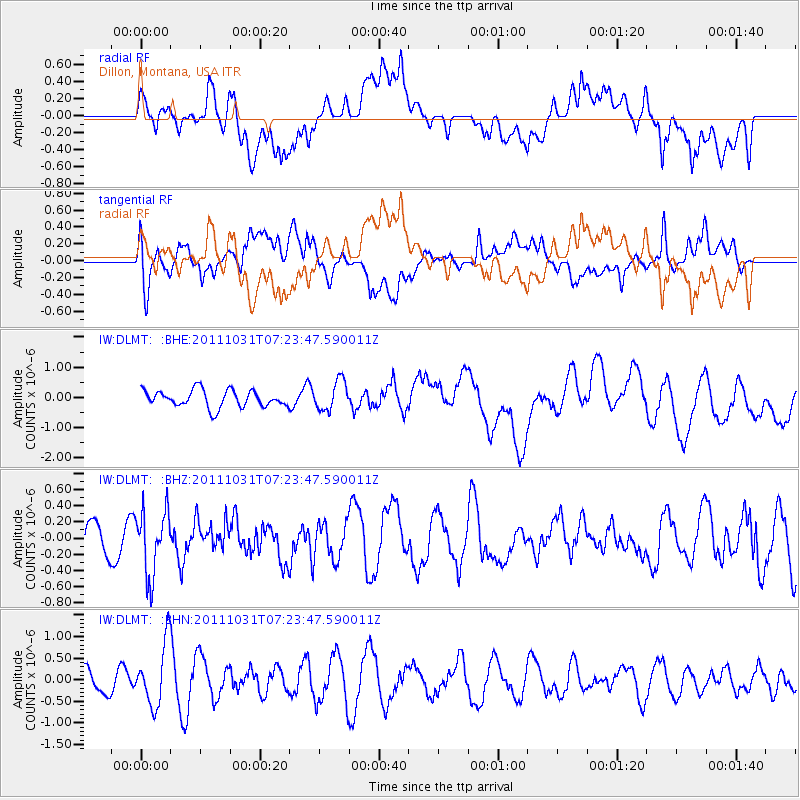
DLMT Dillon, Montana, USA - Earthquake Result Viewer
*The percent match for this event was below the threshold and hence no stack was calculated.
| Earthquake location: |
Rat Islands, Aleutian Islands |
| Earthquake latitude/longitude: |
52.4/177.9 |
| Earthquake time(UTC): |
2011/10/31 (304) 07:16:21 GMT |
| Earthquake Depth: |
159 km |
| Earthquake Magnitude: |
5.8 MB, 5.8 MW, 5.9 MW |
| Earthquake Catalog/Contributor: |
WHDF/NEIC |
|
| Network: |
IW Intermountain West |
| Station: |
DLMT Dillon, Montana, USA |
| Lat/Lon: |
45.36 N/112.60 W |
| Elevation: |
1569 m |
|
| Distance: |
44.6 deg |
| Az: |
70.056 deg |
| Baz: |
305.155 deg |
| Ray Param: |
$rayparam |
*The percent match for this event was below the threshold and hence was not used in the summary stack. |
|
| Radial Match: |
50.58684 % |
| Radial Bump: |
400 |
| Transverse Match: |
51.591225 % |
| Transverse Bump: |
400 |
| SOD ConfigId: |
424168 |
| Insert Time: |
2012-02-17 13:24:30.639 +0000 |
| GWidth: |
2.5 |
| Max Bumps: |
400 |
| Tol: |
0.001 |
|
Signal To Noise
| Channel | StoN | STA | LTA |
| IW:DLMT: :BHZ:20111031T07:23:47.590011Z | 1.0655048 | 3.9741454E-7 | 3.729824E-7 |
| IW:DLMT: :BHN:20111031T07:23:47.590011Z | 2.5010371 | 7.1378696E-7 | 2.853964E-7 |
| IW:DLMT: :BHE:20111031T07:23:47.590011Z | 1.7544174 | 4.9022157E-7 | 2.794213E-7 |
| Arrivals |
| Ps | |
| PpPs | |
| PsPs/PpSs | |


