You are here: Home > Network List > TA - USArray Transportable Network (new EarthScope stations) Stations List
> Station TUL1 Leonard, OK, USA > Earthquake Result Viewer
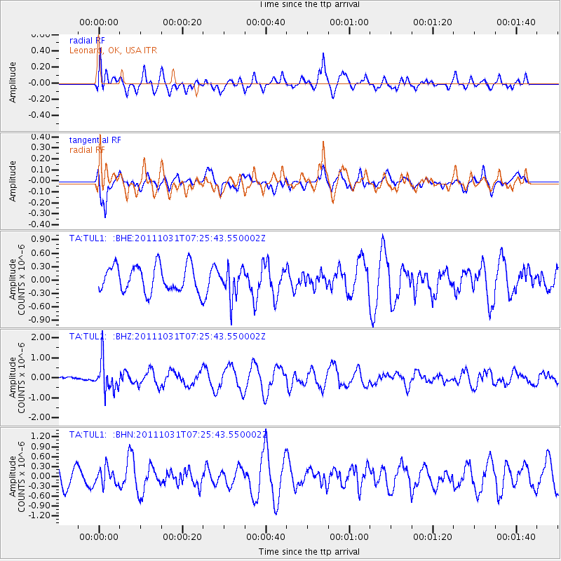
TUL1 Leonard, OK, USA - Earthquake Result Viewer
*The percent match for this event was below the threshold and hence no stack was calculated.
| Earthquake location: |
Rat Islands, Aleutian Islands |
| Earthquake latitude/longitude: |
52.4/177.9 |
| Earthquake time(UTC): |
2011/10/31 (304) 07:16:21 GMT |
| Earthquake Depth: |
159 km |
| Earthquake Magnitude: |
5.8 MB, 5.8 MW, 5.9 MW |
| Earthquake Catalog/Contributor: |
WHDF/NEIC |
|
| Network: |
TA USArray Transportable Network (new EarthScope stations) |
| Station: |
TUL1 Leonard, OK, USA |
| Lat/Lon: |
35.91 N/95.79 W |
| Elevation: |
256 m |
|
| Distance: |
60.4 deg |
| Az: |
68.665 deg |
| Baz: |
315.285 deg |
| Ray Param: |
$rayparam |
*The percent match for this event was below the threshold and hence was not used in the summary stack. |
|
| Radial Match: |
38.467457 % |
| Radial Bump: |
400 |
| Transverse Match: |
60.54859 % |
| Transverse Bump: |
400 |
| SOD ConfigId: |
424168 |
| Insert Time: |
2012-02-17 13:30:27.868 +0000 |
| GWidth: |
2.5 |
| Max Bumps: |
400 |
| Tol: |
0.001 |
|
Signal To Noise
| Channel | StoN | STA | LTA |
| TA:TUL1: :BHZ:20111031T07:25:43.550002Z | 4.4144297 | 7.7331225E-7 | 1.7517829E-7 |
| TA:TUL1: :BHN:20111031T07:25:43.550002Z | 0.7710906 | 2.5427926E-7 | 3.2976573E-7 |
| TA:TUL1: :BHE:20111031T07:25:43.550002Z | 1.1510884 | 3.3897652E-7 | 2.944835E-7 |
| Arrivals |
| Ps | |
| PpPs | |
| PsPs/PpSs | |


