You are here: Home > Network List > TA - USArray Transportable Network (new EarthScope stations) Stations List
> Station WHTX Lake Whitney, Meridian, TX, USA > Earthquake Result Viewer
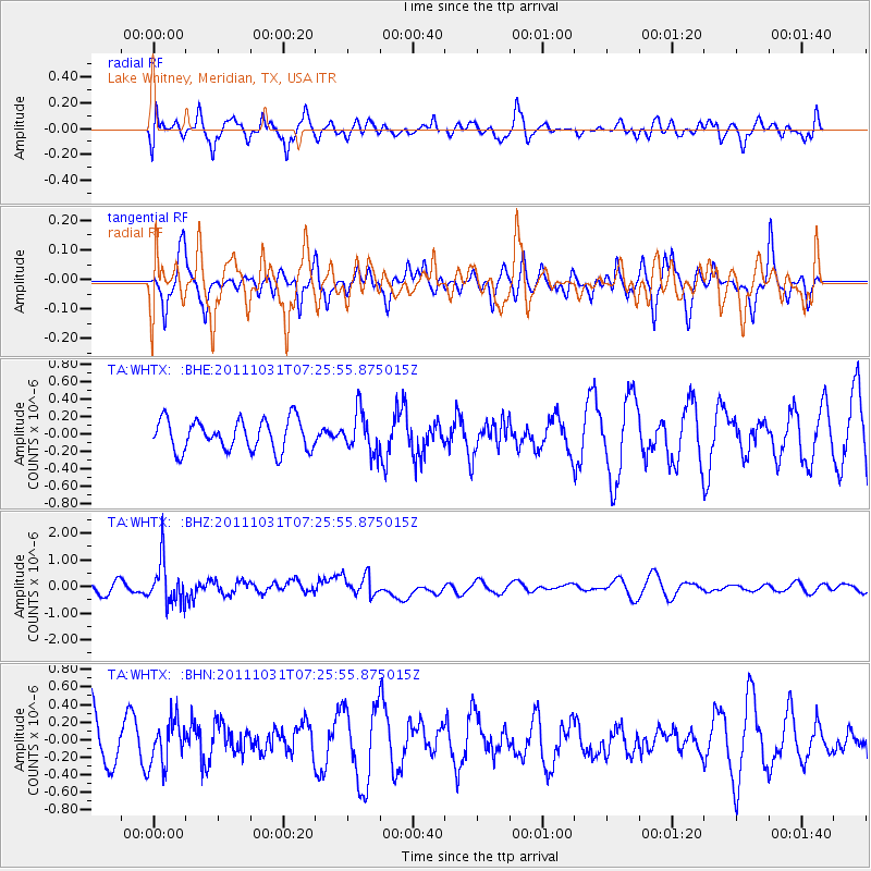
WHTX Lake Whitney, Meridian, TX, USA - Earthquake Result Viewer
*The percent match for this event was below the threshold and hence no stack was calculated.
| Earthquake location: |
Rat Islands, Aleutian Islands |
| Earthquake latitude/longitude: |
52.4/177.9 |
| Earthquake time(UTC): |
2011/10/31 (304) 07:16:21 GMT |
| Earthquake Depth: |
159 km |
| Earthquake Magnitude: |
5.8 MB, 5.8 MW, 5.9 MW |
| Earthquake Catalog/Contributor: |
WHDF/NEIC |
|
| Network: |
TA USArray Transportable Network (new EarthScope stations) |
| Station: |
WHTX Lake Whitney, Meridian, TX, USA |
| Lat/Lon: |
31.99 N/97.46 W |
| Elevation: |
190 m |
|
| Distance: |
62.3 deg |
| Az: |
72.899 deg |
| Baz: |
316.391 deg |
| Ray Param: |
$rayparam |
*The percent match for this event was below the threshold and hence was not used in the summary stack. |
|
| Radial Match: |
40.639774 % |
| Radial Bump: |
394 |
| Transverse Match: |
39.86269 % |
| Transverse Bump: |
310 |
| SOD ConfigId: |
424168 |
| Insert Time: |
2012-02-17 13:30:30.587 +0000 |
| GWidth: |
2.5 |
| Max Bumps: |
400 |
| Tol: |
0.001 |
|
Signal To Noise
| Channel | StoN | STA | LTA |
| TA:WHTX: :BHZ:20111031T07:25:55.875015Z | 3.5994425 | 8.074914E-7 | 2.2433791E-7 |
| TA:WHTX: :BHN:20111031T07:25:55.875015Z | 0.77349776 | 2.5147762E-7 | 3.2511744E-7 |
| TA:WHTX: :BHE:20111031T07:25:55.875015Z | 1.3043497 | 2.3174667E-7 | 1.7767219E-7 |
| Arrivals |
| Ps | |
| PpPs | |
| PsPs/PpSs | |


