You are here: Home > Network List > TA - USArray Transportable Network (new EarthScope stations) Stations List
> Station G03D McMinnville, OR, USA > Earthquake Result Viewer
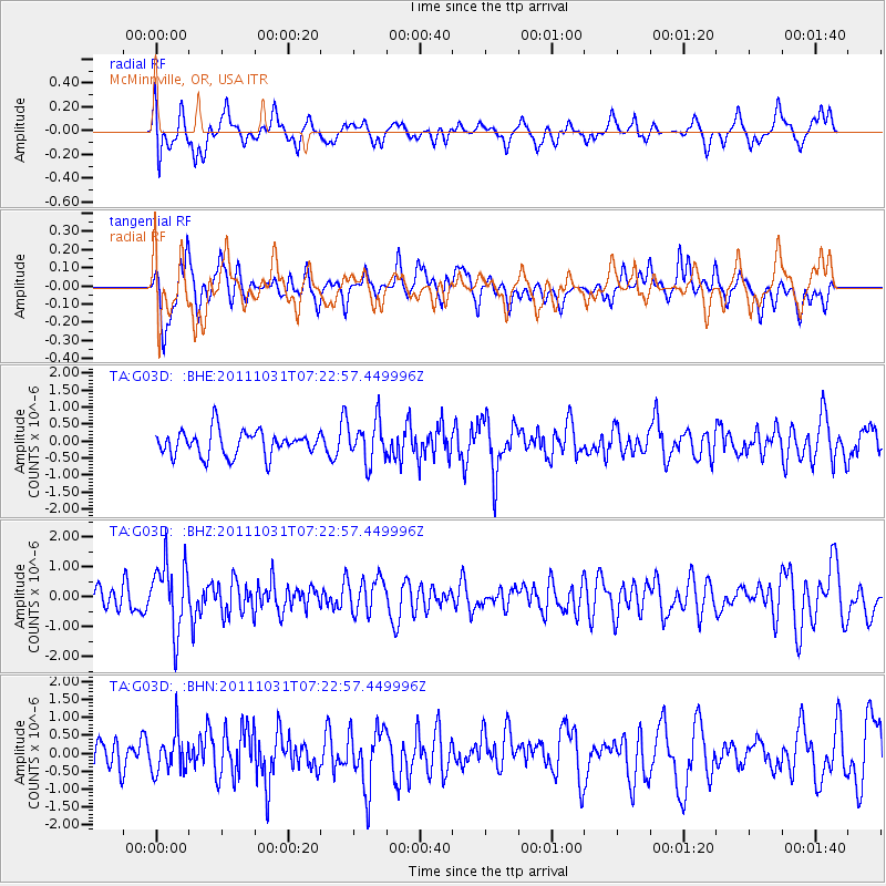
G03D McMinnville, OR, USA - Earthquake Result Viewer
*The percent match for this event was below the threshold and hence no stack was calculated.
| Earthquake location: |
Rat Islands, Aleutian Islands |
| Earthquake latitude/longitude: |
52.4/177.9 |
| Earthquake time(UTC): |
2011/10/31 (304) 07:16:21 GMT |
| Earthquake Depth: |
159 km |
| Earthquake Magnitude: |
5.8 MB, 5.8 MW, 5.9 MW |
| Earthquake Catalog/Contributor: |
WHDF/NEIC |
|
| Network: |
TA USArray Transportable Network (new EarthScope stations) |
| Station: |
G03D McMinnville, OR, USA |
| Lat/Lon: |
45.21 N/123.26 W |
| Elevation: |
222 m |
|
| Distance: |
38.4 deg |
| Az: |
76.559 deg |
| Baz: |
302.467 deg |
| Ray Param: |
$rayparam |
*The percent match for this event was below the threshold and hence was not used in the summary stack. |
|
| Radial Match: |
64.10148 % |
| Radial Bump: |
400 |
| Transverse Match: |
50.752197 % |
| Transverse Bump: |
392 |
| SOD ConfigId: |
424168 |
| Insert Time: |
2012-02-17 13:31:18.911 +0000 |
| GWidth: |
2.5 |
| Max Bumps: |
400 |
| Tol: |
0.001 |
|
Signal To Noise
| Channel | StoN | STA | LTA |
| TA:G03D: :BHZ:20111031T07:22:57.449996Z | 2.8497698 | 1.1272518E-6 | 3.9555889E-7 |
| TA:G03D: :BHN:20111031T07:22:57.449996Z | 1.1621493 | 5.2883246E-7 | 4.5504692E-7 |
| TA:G03D: :BHE:20111031T07:22:57.449996Z | 1.6441256 | 6.0217593E-7 | 3.662591E-7 |
| Arrivals |
| Ps | |
| PpPs | |
| PsPs/PpSs | |


