You are here: Home > Network List > TA - USArray Transportable Network (new EarthScope stations) Stations List
> Station O33A Hebron, NE, USA > Earthquake Result Viewer
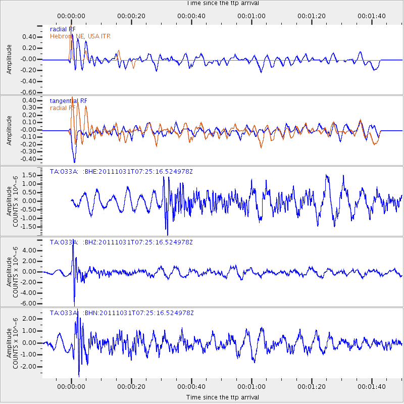
O33A Hebron, NE, USA - Earthquake Result Viewer
*The percent match for this event was below the threshold and hence no stack was calculated.
| Earthquake location: |
Rat Islands, Aleutian Islands |
| Earthquake latitude/longitude: |
52.4/177.9 |
| Earthquake time(UTC): |
2011/10/31 (304) 07:16:21 GMT |
| Earthquake Depth: |
159 km |
| Earthquake Magnitude: |
5.8 MB, 5.8 MW, 5.9 MW |
| Earthquake Catalog/Contributor: |
WHDF/NEIC |
|
| Network: |
TA USArray Transportable Network (new EarthScope stations) |
| Station: |
O33A Hebron, NE, USA |
| Lat/Lon: |
40.08 N/97.58 W |
| Elevation: |
480 m |
|
| Distance: |
56.5 deg |
| Az: |
66.321 deg |
| Baz: |
312.959 deg |
| Ray Param: |
$rayparam |
*The percent match for this event was below the threshold and hence was not used in the summary stack. |
|
| Radial Match: |
45.04762 % |
| Radial Bump: |
400 |
| Transverse Match: |
68.4147 % |
| Transverse Bump: |
400 |
| SOD ConfigId: |
424168 |
| Insert Time: |
2012-02-17 13:36:35.790 +0000 |
| GWidth: |
2.5 |
| Max Bumps: |
400 |
| Tol: |
0.001 |
|
Signal To Noise
| Channel | StoN | STA | LTA |
| TA:O33A: :BHZ:20111031T07:25:16.524978Z | 7.9972878 | 2.1388582E-6 | 2.6744797E-7 |
| TA:O33A: :BHN:20111031T07:25:16.524978Z | 3.9812376 | 1.2140365E-6 | 3.0493945E-7 |
| TA:O33A: :BHE:20111031T07:25:16.524978Z | 2.0499063 | 7.801217E-7 | 3.805646E-7 |
| Arrivals |
| Ps | |
| PpPs | |
| PsPs/PpSs | |


