You are here: Home > Network List > TA - USArray Transportable Network (new EarthScope stations) Stations List
> Station K35A Storm Lake, IA, USA > Earthquake Result Viewer
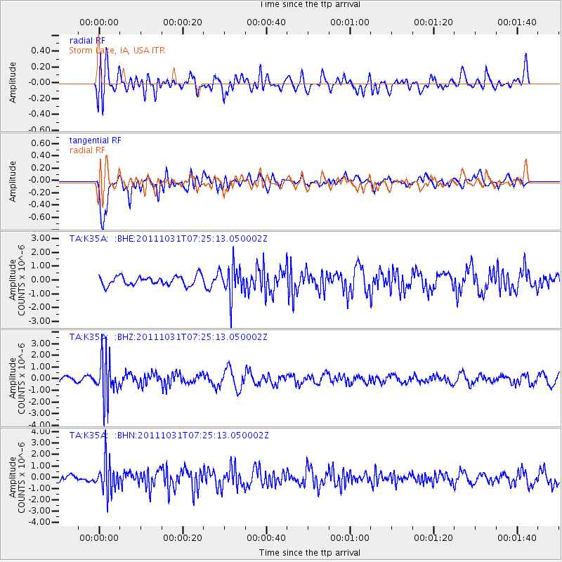
K35A Storm Lake, IA, USA - Earthquake Result Viewer
*The percent match for this event was below the threshold and hence no stack was calculated.
| Earthquake location: |
Rat Islands, Aleutian Islands |
| Earthquake latitude/longitude: |
52.4/177.9 |
| Earthquake time(UTC): |
2011/10/31 (304) 07:16:21 GMT |
| Earthquake Depth: |
159 km |
| Earthquake Magnitude: |
5.8 MB, 5.8 MW, 5.9 MW |
| Earthquake Catalog/Contributor: |
WHDF/NEIC |
|
| Network: |
TA USArray Transportable Network (new EarthScope stations) |
| Station: |
K35A Storm Lake, IA, USA |
| Lat/Lon: |
42.72 N/95.23 W |
| Elevation: |
439 m |
|
| Distance: |
56.0 deg |
| Az: |
62.541 deg |
| Baz: |
312.409 deg |
| Ray Param: |
$rayparam |
*The percent match for this event was below the threshold and hence was not used in the summary stack. |
|
| Radial Match: |
59.646126 % |
| Radial Bump: |
400 |
| Transverse Match: |
81.78942 % |
| Transverse Bump: |
400 |
| SOD ConfigId: |
424168 |
| Insert Time: |
2012-02-17 13:38:44.093 +0000 |
| GWidth: |
2.5 |
| Max Bumps: |
400 |
| Tol: |
0.001 |
|
Signal To Noise
| Channel | StoN | STA | LTA |
| TA:K35A: :BHZ:20111031T07:25:13.050002Z | 6.188481 | 1.6949105E-6 | 2.738815E-7 |
| TA:K35A: :BHN:20111031T07:25:13.050002Z | 3.4549165 | 1.3748875E-6 | 3.97951E-7 |
| TA:K35A: :BHE:20111031T07:25:13.050002Z | 3.2760959 | 1.0941026E-6 | 3.3396535E-7 |
| Arrivals |
| Ps | |
| PpPs | |
| PsPs/PpSs | |


