You are here: Home > Network List > TA - USArray Transportable Network (new EarthScope stations) Stations List
> Station K31A O'Neill, NE, USA > Earthquake Result Viewer
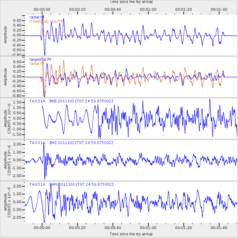
K31A O'Neill, NE, USA - Earthquake Result Viewer
*The percent match for this event was below the threshold and hence no stack was calculated.
| Earthquake location: |
Rat Islands, Aleutian Islands |
| Earthquake latitude/longitude: |
52.4/177.9 |
| Earthquake time(UTC): |
2011/10/31 (304) 07:16:21 GMT |
| Earthquake Depth: |
159 km |
| Earthquake Magnitude: |
5.8 MB, 5.8 MW, 5.9 MW |
| Earthquake Catalog/Contributor: |
WHDF/NEIC |
|
| Network: |
TA USArray Transportable Network (new EarthScope stations) |
| Station: |
K31A O'Neill, NE, USA |
| Lat/Lon: |
42.62 N/98.75 W |
| Elevation: |
580 m |
|
| Distance: |
54.1 deg |
| Az: |
64.744 deg |
| Baz: |
311.291 deg |
| Ray Param: |
$rayparam |
*The percent match for this event was below the threshold and hence was not used in the summary stack. |
|
| Radial Match: |
56.981102 % |
| Radial Bump: |
400 |
| Transverse Match: |
65.63688 % |
| Transverse Bump: |
400 |
| SOD ConfigId: |
424168 |
| Insert Time: |
2012-02-17 13:40:31.396 +0000 |
| GWidth: |
2.5 |
| Max Bumps: |
400 |
| Tol: |
0.001 |
|
Signal To Noise
| Channel | StoN | STA | LTA |
| TA:K31A: :BHZ:20111031T07:24:59.675002Z | 2.6507666 | 9.241361E-7 | 3.4862975E-7 |
| TA:K31A: :BHN:20111031T07:24:59.675002Z | 1.6576177 | 1.2707924E-6 | 7.6663775E-7 |
| TA:K31A: :BHE:20111031T07:24:59.675002Z | 1.7188978 | 9.5060994E-7 | 5.530346E-7 |
| Arrivals |
| Ps | |
| PpPs | |
| PsPs/PpSs | |


