You are here: Home > Network List > TA - USArray Transportable Network (new EarthScope stations) Stations List
> Station G31A Conde, SD, USA > Earthquake Result Viewer
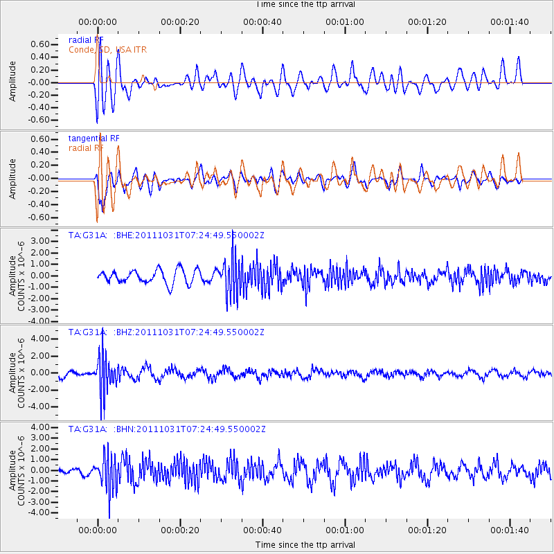
G31A Conde, SD, USA - Earthquake Result Viewer
*The percent match for this event was below the threshold and hence no stack was calculated.
| Earthquake location: |
Rat Islands, Aleutian Islands |
| Earthquake latitude/longitude: |
52.4/177.9 |
| Earthquake time(UTC): |
2011/10/31 (304) 07:16:21 GMT |
| Earthquake Depth: |
159 km |
| Earthquake Magnitude: |
5.8 MB, 5.8 MW, 5.9 MW |
| Earthquake Catalog/Contributor: |
WHDF/NEIC |
|
| Network: |
TA USArray Transportable Network (new EarthScope stations) |
| Station: |
G31A Conde, SD, USA |
| Lat/Lon: |
45.23 N/98.21 W |
| Elevation: |
393 m |
|
| Distance: |
52.8 deg |
| Az: |
61.967 deg |
| Baz: |
310.015 deg |
| Ray Param: |
$rayparam |
*The percent match for this event was below the threshold and hence was not used in the summary stack. |
|
| Radial Match: |
59.989624 % |
| Radial Bump: |
400 |
| Transverse Match: |
67.23979 % |
| Transverse Bump: |
400 |
| SOD ConfigId: |
424168 |
| Insert Time: |
2012-02-17 13:42:03.210 +0000 |
| GWidth: |
2.5 |
| Max Bumps: |
400 |
| Tol: |
0.001 |
|
Signal To Noise
| Channel | StoN | STA | LTA |
| TA:G31A: :BHZ:20111031T07:24:49.550002Z | 5.723387 | 2.0934872E-6 | 3.6577768E-7 |
| TA:G31A: :BHN:20111031T07:24:49.550002Z | 4.051416 | 1.5252282E-6 | 3.7646797E-7 |
| TA:G31A: :BHE:20111031T07:24:49.550002Z | 2.6106577 | 1.532179E-6 | 5.8689386E-7 |
| Arrivals |
| Ps | |
| PpPs | |
| PsPs/PpSs | |


