You are here: Home > Network List > TA - USArray Transportable Network (new EarthScope stations) Stations List
> Station K37A Belmond, IA, USA > Earthquake Result Viewer
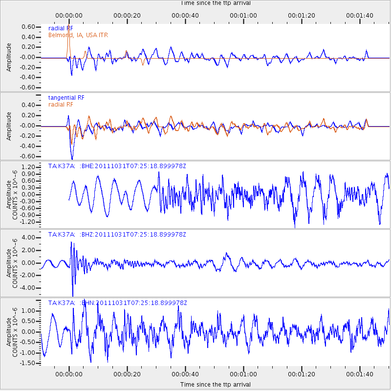
K37A Belmond, IA, USA - Earthquake Result Viewer
*The percent match for this event was below the threshold and hence no stack was calculated.
| Earthquake location: |
Rat Islands, Aleutian Islands |
| Earthquake latitude/longitude: |
52.4/177.9 |
| Earthquake time(UTC): |
2011/10/31 (304) 07:16:21 GMT |
| Earthquake Depth: |
159 km |
| Earthquake Magnitude: |
5.8 MB, 5.8 MW, 5.9 MW |
| Earthquake Catalog/Contributor: |
WHDF/NEIC |
|
| Network: |
TA USArray Transportable Network (new EarthScope stations) |
| Station: |
K37A Belmond, IA, USA |
| Lat/Lon: |
42.77 N/93.64 W |
| Elevation: |
365 m |
|
| Distance: |
56.9 deg |
| Az: |
61.546 deg |
| Baz: |
312.937 deg |
| Ray Param: |
$rayparam |
*The percent match for this event was below the threshold and hence was not used in the summary stack. |
|
| Radial Match: |
64.62857 % |
| Radial Bump: |
400 |
| Transverse Match: |
63.193935 % |
| Transverse Bump: |
400 |
| SOD ConfigId: |
424168 |
| Insert Time: |
2012-02-17 13:44:09.065 +0000 |
| GWidth: |
2.5 |
| Max Bumps: |
400 |
| Tol: |
0.001 |
|
Signal To Noise
| Channel | StoN | STA | LTA |
| TA:K37A: :BHZ:20111031T07:25:18.899978Z | 3.8483977 | 1.6997178E-6 | 4.4166896E-7 |
| TA:K37A: :BHN:20111031T07:25:18.899978Z | 0.8888345 | 4.9509987E-7 | 5.570215E-7 |
| TA:K37A: :BHE:20111031T07:25:18.899978Z | 1.0373932 | 4.747379E-7 | 4.5762582E-7 |
| Arrivals |
| Ps | |
| PpPs | |
| PsPs/PpSs | |


