You are here: Home > Network List > TA - USArray Transportable Network (new EarthScope stations) Stations List
> Station 146A Union, MS, USA > Earthquake Result Viewer
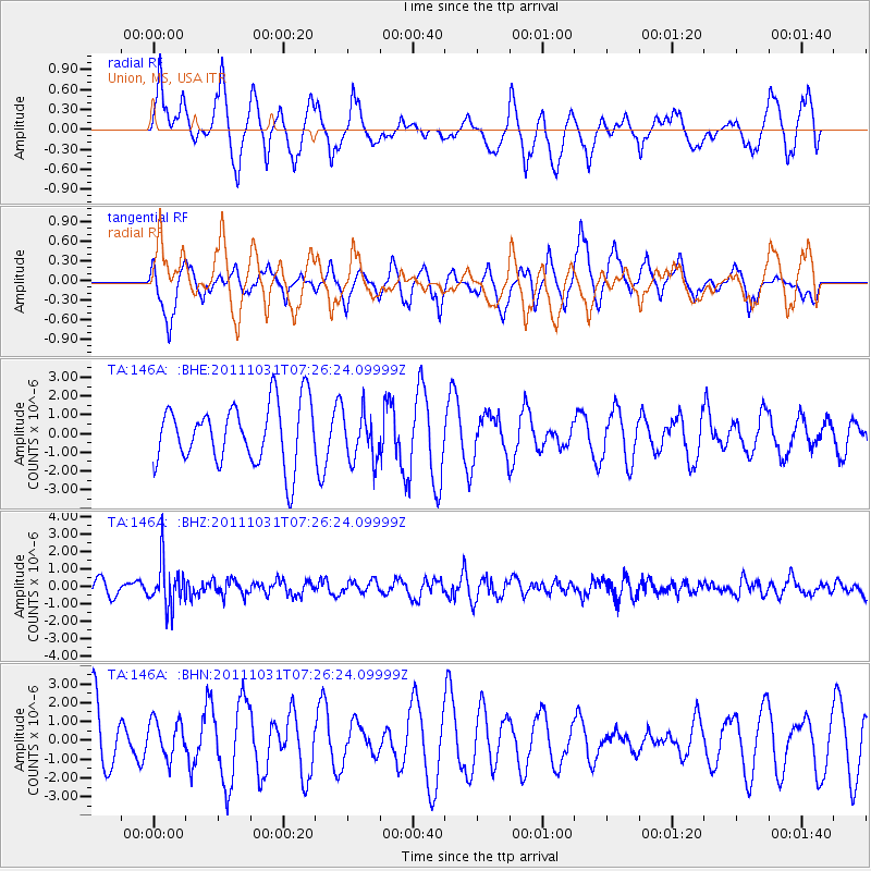
146A Union, MS, USA - Earthquake Result Viewer
*The percent match for this event was below the threshold and hence no stack was calculated.
| Earthquake location: |
Rat Islands, Aleutian Islands |
| Earthquake latitude/longitude: |
52.4/177.9 |
| Earthquake time(UTC): |
2011/10/31 (304) 07:16:21 GMT |
| Earthquake Depth: |
159 km |
| Earthquake Magnitude: |
5.8 MB, 5.8 MW, 5.9 MW |
| Earthquake Catalog/Contributor: |
WHDF/NEIC |
|
| Network: |
TA USArray Transportable Network (new EarthScope stations) |
| Station: |
146A Union, MS, USA |
| Lat/Lon: |
32.64 N/89.06 W |
| Elevation: |
164 m |
|
| Distance: |
66.6 deg |
| Az: |
66.628 deg |
| Baz: |
318.155 deg |
| Ray Param: |
$rayparam |
*The percent match for this event was below the threshold and hence was not used in the summary stack. |
|
| Radial Match: |
42.536137 % |
| Radial Bump: |
395 |
| Transverse Match: |
76.63582 % |
| Transverse Bump: |
400 |
| SOD ConfigId: |
424168 |
| Insert Time: |
2012-02-17 13:48:28.470 +0000 |
| GWidth: |
2.5 |
| Max Bumps: |
400 |
| Tol: |
0.001 |
|
Signal To Noise
| Channel | StoN | STA | LTA |
| TA:146A: :BHZ:20111031T07:26:24.09999Z | 3.820104 | 1.2807097E-6 | 3.352552E-7 |
| TA:146A: :BHN:20111031T07:26:24.09999Z | 0.5247255 | 9.412424E-7 | 1.7937806E-6 |
| TA:146A: :BHE:20111031T07:26:24.09999Z | 0.81583744 | 1.315198E-6 | 1.6120835E-6 |
| Arrivals |
| Ps | |
| PpPs | |
| PsPs/PpSs | |


