You are here: Home > Network List > TA - USArray Transportable Network (new EarthScope stations) Stations List
> Station X41A Kaden, Bauxite, AR, USA > Earthquake Result Viewer
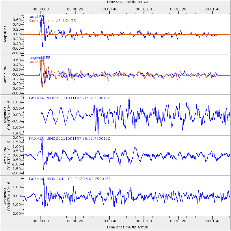
X41A Kaden, Bauxite, AR, USA - Earthquake Result Viewer
*The percent match for this event was below the threshold and hence no stack was calculated.
| Earthquake location: |
Rat Islands, Aleutian Islands |
| Earthquake latitude/longitude: |
52.4/177.9 |
| Earthquake time(UTC): |
2011/10/31 (304) 07:16:21 GMT |
| Earthquake Depth: |
159 km |
| Earthquake Magnitude: |
5.8 MB, 5.8 MW, 5.9 MW |
| Earthquake Catalog/Contributor: |
WHDF/NEIC |
|
| Network: |
TA USArray Transportable Network (new EarthScope stations) |
| Station: |
X41A Kaden, Bauxite, AR, USA |
| Lat/Lon: |
34.49 N/92.51 W |
| Elevation: |
102 m |
|
| Distance: |
63.3 deg |
| Az: |
67.589 deg |
| Baz: |
316.66 deg |
| Ray Param: |
$rayparam |
*The percent match for this event was below the threshold and hence was not used in the summary stack. |
|
| Radial Match: |
55.47098 % |
| Radial Bump: |
400 |
| Transverse Match: |
72.2482 % |
| Transverse Bump: |
400 |
| SOD ConfigId: |
424168 |
| Insert Time: |
2012-02-17 13:50:27.160 +0000 |
| GWidth: |
2.5 |
| Max Bumps: |
400 |
| Tol: |
0.001 |
|
Signal To Noise
| Channel | StoN | STA | LTA |
| TA:X41A: :BHZ:20111031T07:26:02.750015Z | 2.7672832 | 8.5687896E-7 | 3.0964628E-7 |
| TA:X41A: :BHN:20111031T07:26:02.750015Z | 2.974926 | 8.4797523E-7 | 2.8504078E-7 |
| TA:X41A: :BHE:20111031T07:26:02.750015Z | 1.8425918 | 6.230757E-7 | 3.381518E-7 |
| Arrivals |
| Ps | |
| PpPs | |
| PsPs/PpSs | |


