You are here: Home > Network List > TA - USArray Transportable Network (new EarthScope stations) Stations List
> Station H38A Maiden Rock, WI, USA > Earthquake Result Viewer
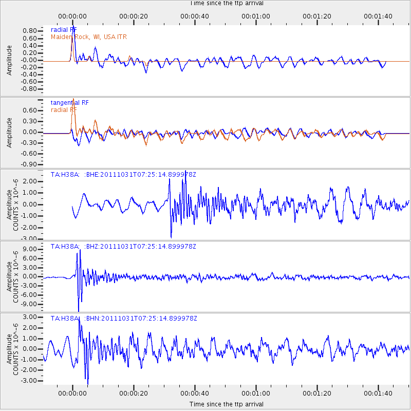
H38A Maiden Rock, WI, USA - Earthquake Result Viewer
*The percent match for this event was below the threshold and hence no stack was calculated.
| Earthquake location: |
Rat Islands, Aleutian Islands |
| Earthquake latitude/longitude: |
52.4/177.9 |
| Earthquake time(UTC): |
2011/10/31 (304) 07:16:21 GMT |
| Earthquake Depth: |
159 km |
| Earthquake Magnitude: |
5.8 MB, 5.8 MW, 5.9 MW |
| Earthquake Catalog/Contributor: |
WHDF/NEIC |
|
| Network: |
TA USArray Transportable Network (new EarthScope stations) |
| Station: |
H38A Maiden Rock, WI, USA |
| Lat/Lon: |
44.68 N/92.28 W |
| Elevation: |
333 m |
|
| Distance: |
56.3 deg |
| Az: |
59.067 deg |
| Baz: |
312.505 deg |
| Ray Param: |
$rayparam |
*The percent match for this event was below the threshold and hence was not used in the summary stack. |
|
| Radial Match: |
59.382656 % |
| Radial Bump: |
400 |
| Transverse Match: |
58.120327 % |
| Transverse Bump: |
400 |
| SOD ConfigId: |
424168 |
| Insert Time: |
2012-02-17 13:53:51.017 +0000 |
| GWidth: |
2.5 |
| Max Bumps: |
400 |
| Tol: |
0.001 |
|
Signal To Noise
| Channel | StoN | STA | LTA |
| TA:H38A: :BHZ:20111031T07:25:14.899978Z | 13.396738 | 4.010858E-6 | 2.9939062E-7 |
| TA:H38A: :BHN:20111031T07:25:14.899978Z | 2.4050295 | 1.3993756E-6 | 5.8185384E-7 |
| TA:H38A: :BHE:20111031T07:25:14.899978Z | 2.2983043 | 1.0018916E-6 | 4.359264E-7 |
| Arrivals |
| Ps | |
| PpPs | |
| PsPs/PpSs | |


