You are here: Home > Network List > TA - USArray Transportable Network (new EarthScope stations) Stations List
> Station G41A Antigo, WI, USA > Earthquake Result Viewer
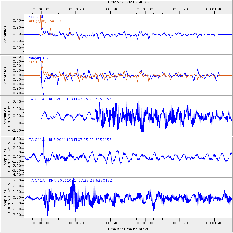
G41A Antigo, WI, USA - Earthquake Result Viewer
*The percent match for this event was below the threshold and hence no stack was calculated.
| Earthquake location: |
Rat Islands, Aleutian Islands |
| Earthquake latitude/longitude: |
52.4/177.9 |
| Earthquake time(UTC): |
2011/10/31 (304) 07:16:21 GMT |
| Earthquake Depth: |
159 km |
| Earthquake Magnitude: |
5.8 MB, 5.8 MW, 5.9 MW |
| Earthquake Catalog/Contributor: |
WHDF/NEIC |
|
| Network: |
TA USArray Transportable Network (new EarthScope stations) |
| Station: |
G41A Antigo, WI, USA |
| Lat/Lon: |
45.21 N/89.18 W |
| Elevation: |
464 m |
|
| Distance: |
57.5 deg |
| Az: |
56.807 deg |
| Baz: |
313.454 deg |
| Ray Param: |
$rayparam |
*The percent match for this event was below the threshold and hence was not used in the summary stack. |
|
| Radial Match: |
39.40866 % |
| Radial Bump: |
400 |
| Transverse Match: |
65.22896 % |
| Transverse Bump: |
400 |
| SOD ConfigId: |
424168 |
| Insert Time: |
2012-02-17 13:54:29.478 +0000 |
| GWidth: |
2.5 |
| Max Bumps: |
400 |
| Tol: |
0.001 |
|
Signal To Noise
| Channel | StoN | STA | LTA |
| TA:G41A: :BHZ:20111031T07:25:23.625015Z | 3.558744 | 1.2189797E-6 | 3.425309E-7 |
| TA:G41A: :BHN:20111031T07:25:23.625015Z | 3.2052827 | 9.0131164E-7 | 2.8119567E-7 |
| TA:G41A: :BHE:20111031T07:25:23.625015Z | 2.3459423 | 7.014433E-7 | 2.990028E-7 |
| Arrivals |
| Ps | |
| PpPs | |
| PsPs/PpSs | |


