You are here: Home > Network List > G - GEOSCOPE Stations List
> Station HYB Hyderabad, India > Earthquake Result Viewer
HYB Hyderabad, India - Earthquake Result Viewer
| Earthquake location: |
Solomon Islands |
| Earthquake latitude/longitude: |
-7.7/159.5 |
| Earthquake time(UTC): |
2005/01/22 (022) 20:30:17 GMT |
| Earthquake Depth: |
29 km |
| Earthquake Magnitude: |
6.2 MB, 6.5 MS, 6.4 MW, 6.4 MW |
| Earthquake Catalog/Contributor: |
WHDF/NEIC |
|
| Network: |
G GEOSCOPE |
| Station: |
HYB Hyderabad, India |
| Lat/Lon: |
17.42 N/78.55 E |
| Elevation: |
510 m |
|
| Distance: |
83.7 deg |
| Az: |
288.473 deg |
| Baz: |
100.084 deg |
| Ray Param: |
0.04595796 |
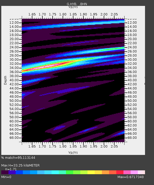
| Estimated Moho Depth: |
33.25 km |
| Estimated Crust Vp/Vs: |
1.71 |
| Assumed Crust Vp: |
6.459 km/s |
| Estimated Crust Vs: |
3.777 km/s |
| Estimated Crust Poisson's Ratio: |
0.24 |
|
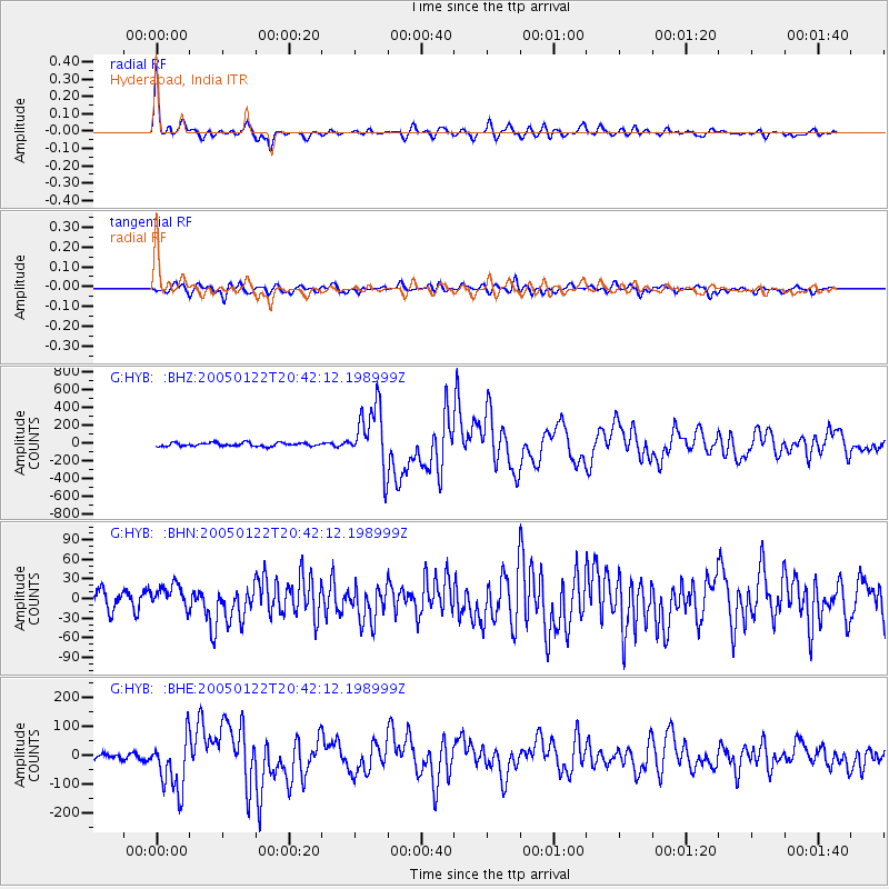
| Radial Match: |
95.113144 % |
| Radial Bump: |
400 |
| Transverse Match: |
83.86117 % |
| Transverse Bump: |
400 |
| SOD ConfigId: |
39739 |
| Insert Time: |
2010-02-26 22:46:02.919 +0000 |
| GWidth: |
2.5 |
| Max Bumps: |
400 |
| Tol: |
0.001 |
|
Signal To Noise
| Channel | StoN | STA | LTA |
| G:HYB: :BHN:20050122T20:42:12.198999Z | 1.7423842 | 19.377752 | 11.121401 |
| G:HYB: :BHE:20050122T20:42:12.198999Z | 7.5259447 | 95.13359 | 12.640751 |
| G:HYB: :BHZ:20050122T20:42:12.198999Z | 17.307762 | 346.43643 | 20.016247 |
| Arrivals |
| Ps | 3.8 SECOND |
| PpPs | 14 SECOND |
| PsPs/PpSs | 17 SECOND |


