You are here: Home > Network List > G - GEOSCOPE Stations List
> Station INU Inuyama, Japan > Earthquake Result Viewer
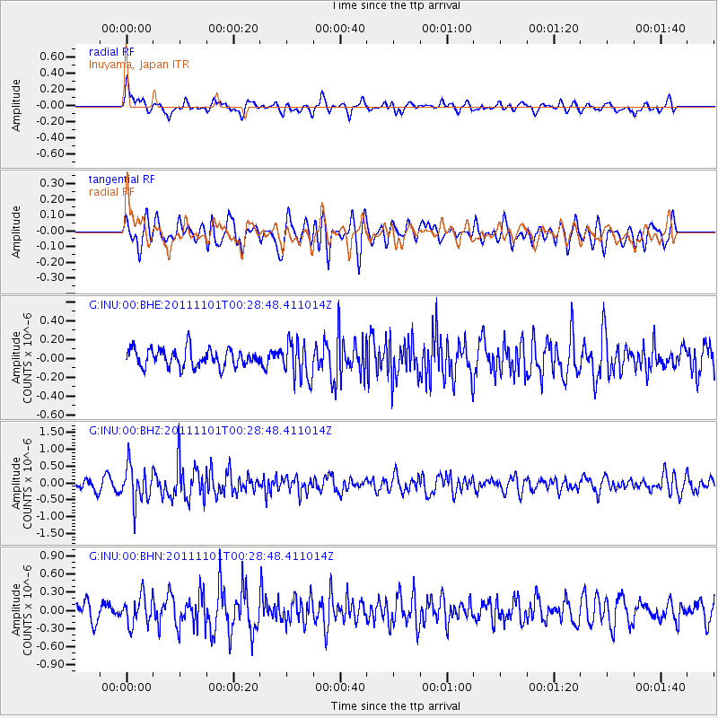
INU Inuyama, Japan - Earthquake Result Viewer
*The percent match for this event was below the threshold and hence no stack was calculated.
| Earthquake location: |
Northern Xinjiang, China |
| Earthquake latitude/longitude: |
43.6/82.4 |
| Earthquake time(UTC): |
2011/11/01 (305) 00:21:28 GMT |
| Earthquake Depth: |
28 km |
| Earthquake Magnitude: |
6.0 MB, 5.4 MS, 5.6 MW, 5.4 MW |
| Earthquake Catalog/Contributor: |
WHDF/NEIC |
|
| Network: |
G GEOSCOPE |
| Station: |
INU Inuyama, Japan |
| Lat/Lon: |
35.35 N/137.03 E |
| Elevation: |
132 m |
|
| Distance: |
42.3 deg |
| Az: |
82.109 deg |
| Baz: |
298.407 deg |
| Ray Param: |
$rayparam |
*The percent match for this event was below the threshold and hence was not used in the summary stack. |
|
| Radial Match: |
60.950253 % |
| Radial Bump: |
400 |
| Transverse Match: |
64.50714 % |
| Transverse Bump: |
400 |
| SOD ConfigId: |
424168 |
| Insert Time: |
2012-02-17 14:09:42.918 +0000 |
| GWidth: |
2.5 |
| Max Bumps: |
400 |
| Tol: |
0.001 |
|
Signal To Noise
| Channel | StoN | STA | LTA |
| G:INU:00:BHZ:20111101T00:28:48.411014Z | 4.5751967 | 5.5490113E-7 | 1.2128466E-7 |
| G:INU:00:BHN:20111101T00:28:48.411014Z | 1.5777243 | 2.4116048E-7 | 1.5285337E-7 |
| G:INU:00:BHE:20111101T00:28:48.411014Z | 2.1276596 | 2.0180464E-7 | 9.484818E-8 |
| Arrivals |
| Ps | |
| PpPs | |
| PsPs/PpSs | |


