You are here: Home > Network List > TA - USArray Transportable Network (new EarthScope stations) Stations List
> Station O03E Paynes Creek, CA, USA > Earthquake Result Viewer
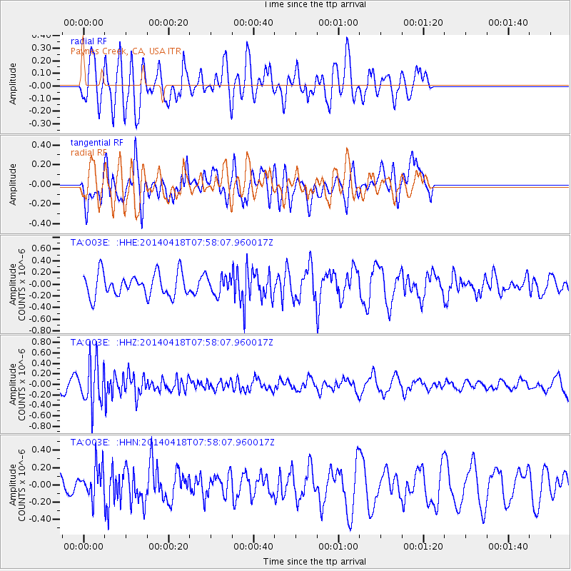
O03E Paynes Creek, CA, USA - Earthquake Result Viewer
*The percent match for this event was below the threshold and hence no stack was calculated.
| Earthquake location: |
Santiago Del Estero Prov., Arg. |
| Earthquake latitude/longitude: |
-27.7/-62.8 |
| Earthquake time(UTC): |
2014/04/18 (108) 07:46:57 GMT |
| Earthquake Depth: |
610 km |
| Earthquake Magnitude: |
5.6 MW |
| Earthquake Catalog/Contributor: |
ISC/ISC |
|
| Network: |
TA USArray Transportable Network (new EarthScope stations) |
| Station: |
O03E Paynes Creek, CA, USA |
| Lat/Lon: |
40.29 N/121.80 W |
| Elevation: |
967 m |
|
| Distance: |
87.1 deg |
| Az: |
318.973 deg |
| Baz: |
130.472 deg |
| Ray Param: |
$rayparam |
*The percent match for this event was below the threshold and hence was not used in the summary stack. |
|
| Radial Match: |
57.40817 % |
| Radial Bump: |
400 |
| Transverse Match: |
63.614918 % |
| Transverse Bump: |
400 |
| SOD ConfigId: |
3390531 |
| Insert Time: |
2019-04-11 11:00:51.892 +0000 |
| GWidth: |
2.5 |
| Max Bumps: |
400 |
| Tol: |
0.001 |
|
Signal To Noise
| Channel | StoN | STA | LTA |
| TA:O03E: :HHZ:20140418T07:58:07.960017Z | 3.1933532 | 4.0891368E-7 | 1.280515E-7 |
| TA:O03E: :HHN:20140418T07:58:07.960017Z | 2.177419 | 1.8996505E-7 | 8.724322E-8 |
| TA:O03E: :HHE:20140418T07:58:07.960017Z | 0.7538974 | 1.4828655E-7 | 1.9669325E-7 |
| Arrivals |
| Ps | |
| PpPs | |
| PsPs/PpSs | |


